What Driving on São Miguel Is Actually Like
What is driving on São Miguel actually like?
Slow, narrow and scenic rather than difficult: single-lane country roads wind through farmland with cattle sometimes on the tarmac, fog can close the passes at Lagoa do Fogo and Sete Cidades with little warning, and fuel stations thin out fast outside Ponta Delgada, Ribeira Grande and Lagoa. Most visitors adjust within a day.
Behind the Wheel on a Working Island
Renting a car on São Miguil is straightforward — that part is covered in renting a car on São Miguel. What catches first-time visitors off guard is not the paperwork but the driving itself, once the road narrows past the airport roundabout and the fields start pressing in on both sides. This island is not a wilderness circuit and it is not an alpine drive. It is farmed and inhabited, a patchwork of pasture, hedgerow and small parishes where the road network was built for people who live there, not for tour buses. Understanding that one fact explains almost everything else about getting around by car.
Most of what follows applies once you leave the handful of wider roads around Ponta Delgada, Ribeira Grande and Lagoa. On those stretches — including the dual-carriageway via rápida — driving feels close to mainland Europe. Everywhere else, it does not.
Narrow, Winding, and Built for the Land, Not the Traffic
The great majority of São Miguel’s roads are the EN1-1A, the ring road, and a web of parish roads that branch off it toward the coast, the caldeiras and the viewpoints. Away from the via rápida, expect:
- Single carriageways with painted centre lines that often disappear on tighter bends
- Stone walls, hydrangea hedges or drop-offs sitting directly at the road edge, with no shoulder to bail onto
- Blind corners around farm buildings and church squares in every parish
- Frequent, tight switchbacks on any road that climbs from the coast toward the interior
None of this is unsafe if you drive to the road rather than to a posted number. Locals treat 40–50 km/h as a reasonable cruising speed on these roads, not a crawl, and rental cars are almost always compact for exactly this reason. A route that looks like a 25-minute hop on a map — say, from Ponta Delgada to Sete Cidades — routinely takes closer to 45 once the curves and a tractor or two are factored in. Build that slack into any full-island itinerary rather than discovering it at the wheel.
There is no mountain pass here in the alpine sense: no snow gates, no avalanche closures, no tunnel bored through a ridge. The island’s highest paved crossings sit at a few hundred metres, not a few thousand, and the hazard they carry is weather, not altitude — which is exactly why it catches people out.
Cattle on the Road Is Normal, Not an Emergency
São Miguel’s economy still runs substantially on dairy and beef, and that farming reality shows up directly on the tarmac. It is entirely ordinary to round a bend near Nordeste, the pastures around Achada, or the lanes behind Ribeira Grande and meet a small herd of cattle being walked along the public road, sometimes with a farmer or a dog managing them from behind, sometimes loose for a short stretch between gates.
The correct response is the one locals use: slow right down, hold a steady line, and wait. Herds move off the road on their own with a little patience, and horns rarely help. This is one reason average speeds stay low across the island even where the road surface would allow more — cattle, farm machinery and the occasional loose dog are part of daily traffic here, not an anomaly to plan around once and forget. It is also a useful reminder of what this island actually is: read more on why São Miguel is farmed, not a wilderness, and on the handful of genuine outdoor hazards in is São Miguel safe.
Fog Closes the Passes Without Much Notice
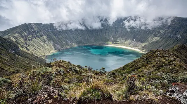
The two places this matters most are the road up to the Lagoa do Fogo viewpoint and the climb to the Sete Cidades caldera rim, including the approach to Vista do Rei. Both roads gain altitude quickly from a relatively low base, and both routinely pass into cloud even when the coast below is clear and sunny.
A few things are worth knowing before setting out:
| Situation | What tends to happen |
|---|---|
| Clear morning at sea level | No guarantee the pass is clear — check before committing the whole visit to a view |
| Cloud already visible on the ridge | Good chance the viewpoint is fogged in on arrival |
| Sudden fog while driving up | Slow down, use low beams, and be ready to turn back rather than push through blind |
| Access road gated or signed closed | Treat it as final — these closures follow wind and visibility, not a schedule |
Lagoa do Fogo has no facilities of any kind at the top — no café, no gate attendant to ask, nothing but the car park and the crater below when the cloud lifts. Because of this, day-trip pages built around the crater lake are written to plan around fog rather than promise a view; see what to expect on a Lagoa do Fogo day trip and the viewpoint when the clouds clear. The same logic applies at Sete Cidades: build in a second attempt later the same day, or on a different day, rather than driving up once and writing the caldera off if the first pass is white-out.
None of this is dangerous driving in the way an icy alpine pass would be — there is no snow, no ice, and no serious gradient by continental standards. The risk is purely reduced visibility on a narrow road with a drop on one side, which is manageable at low speed and unmanageable at the speed a clear straight elsewhere on the island might tempt you toward.
Fuel Stations Thin Out Fast — Nordeste Especially
Fuel stations cluster around Ponta Delgada, Ribeira Grande and Lagoa, and thin out sharply everywhere else. This is most noticeable on a Nordeste circuit, where the road threads through small parishes for long stretches without a station in sight, and again on the loop out toward Faial da Terra and the eastern tip.
The practical habit locals and experienced visitors share is the same one: fill the tank before leaving the main towns whenever a route touches Nordeste, Povoação or the interior, rather than assuming “something will turn up.” It usually does, eventually — but “eventually” is not a plan when the gauge is already low on a road with patchy phone signal. A Nordeste coastal day trip or a run out to the Ponta do Sossego and Ponta da Madrugada viewpoints is a full day of driving in itself; start it with a full tank, not a plan to find one halfway round.
The Road Network in Practice
| Road type | Where | What it feels like |
|---|---|---|
| Via rápida (dual carriageway) | Ponta Delgada–Ribeira Grande–Lagoa | Fast, wide, closest thing to mainland driving |
| EN1-1A ring road | Around the whole island | Two-lane, curving, the island’s main artery |
| Parish and coastal roads | Everywhere off the ring road | Narrow, winding, farm traffic and cattle possible |
| Caldera and viewpoint access roads | Lagoa do Fogo, Sete Cidades rim, Nordeste viewpoints | Steep, tight switchbacks, fog risk |
There is no train on São Miguel, and the bus network — covered separately in the bus guide — runs on school and work timetables rather than sightseeing ones. That combination is exactly why most visitors end up behind the wheel for at least part of a trip; the question of which approach suits a given itinerary is worked through in self-drive versus guided tours.
What the Ring Road Actually Passes Through
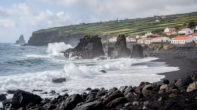
The EN1-1A does not skirt the coast in a straight line so much as stitch together the working towns and villages that give São Miguel its rhythm. Heading north from Ponta Delgada, the road runs through Rabo de Peixe, still a working fishing town, and on to Capelas, where an old whaling station sits at the edge of the village — a reminder that this coastline earned its living from the sea long before rental cars appeared on it. Neither stop needs much of a detour; both sit directly on the route most drivers already take toward the north coast or Sete Cidades.
South and east of Ponta Delgada, the ring road threads past Água de Pau and into Vila Franca do Campo, the island’s capital until 1522 and still one of its most driveable small towns, before continuing on toward Povoação and, on the loop over the ridge, Ribeira Quente, the beach parish on the far side of Furnas from the caldera itself.
None of these stretches carry the switchback intensity of the caldera access roads — they are ordinary two-lane road through ordinary villages — but the same rule applies everywhere on the ring road: a church square or a farm gate can put a slow-moving tractor or a parked delivery van in the lane with no warning, so the same unhurried pace that works near Nordeste works here too.
Parking Once You Reach a Town
Driving the open road and parking in a town centre are two different skills on São Miguel, and the second one surprises people almost as often as the first. Ponta Delgada’s old town was built long before cars existed, and its narrow one-way streets near the Portas da Cidade reward patience over persistence; the detail of where to actually leave the car is covered separately in parking in Ponta Delgada. Smaller towns and villages are gentler — Ribeira Grande, Lagoa and Vila Franca do Campo all have room to pull in near the centre — but village squares fill quickly around market hours and church services, and a car left blocking a narrow lane on a busy morning will not stay unnoticed for long.
Signal, Navigation, and Not Relying on the Bus as a Backup
Mobile signal on São Miguel is reliable around Ponta Delgada, Ribeira Grande and the main coastal towns, and noticeably patchier once a route climbs into the interior toward Lagoa do Fogo, the Sete Cidades rim, or the back roads around Nordeste. A live map that depends on a data connection can drop out at exactly the point a junction needs it most, so downloading offline maps for the island before setting out is worth the two minutes it takes.
It is also worth being honest about the alternative: the bus network exists, but as noted above it runs on school and work timetables, not sightseeing ones, and treating it as a fallback for a day the rental car cannot cover is usually a disappointment — see why the rental car is the default, not the bus for the reasoning in full.
A Realistic Day Behind the Wheel
A typical loop — Ponta Delgada out to Sete Cidades, across to Mosteiros, and back along the north coast — covers barely 100 km on the map but fills most of a day once stops, curves and the odd tractor are counted. The same is true heading east: Ponta Delgada to Furnas and on to Nordeste is not a quick there-and-back, it is a full day’s full-island itinerary building block. The weather compounds this — it can be raining at Furnas while Ponta Delgada sits in sunshine twenty minutes away, so a route plan needs slack for both the road and the sky changing without warning.
None of this should read as a warning against self-driving. It is the practical default on the island for good reason: it is the only way to reach most viewpoints, caldeiras and coastal spots on your own schedule. It simply rewards a slower, more attentive style of driving than a highway trip would, and a realistic sense of how long each leg actually takes.
When It Makes Sense to Let Someone Else Drive
Arriving by air is the one leg most visitors skip the car for entirely — a pre-booked airport transfer to or from Ponta Delgada removes the least enjoyable driving of the whole trip, the tired first hour after a long flight.
Beyond that, some routes are simply easier handed to a local driver who already knows where the fog usually sits and which lanes get busy with farm traffic: a guided day tour through Sete Cidades and the western viewpoints covers the caldera roads without anyone in the group needing to watch the mirrors on a switchback, a full-island jeep tour takes on the roughest access tracks in a vehicle built for them, and a half-day tour to Furnas lets everyone focus on the cozido and the thermal park rather than the road in.
Mixing a few guided days into an otherwise self-driven trip is a common, sensible compromise rather than an either-or choice — see self-drive versus guided tours for how to split a week between the two.
Driving Conditions on São Miguel: Common Questions
Are the roads on São Miguel dangerous?
Not dangerous so much as demanding attention. Lanes are narrow, verges are close, and stone walls or hedgerows leave no margin for error, so speeds stay low almost everywhere outside the via rápida.
Will I really encounter cattle on the road?
Yes, especially on minor roads near Nordeste, Achada and the interior pastures. Herds are moved along public roads on foot, sometimes with a farmer walking behind them, and traffic simply waits.
Can fog really close a mountain pass on São Miguel?
Yes. The roads up to Lagoa do Fogo and the Sete Cidades caldera rim climb into cloud level quickly, and low visibility or an active closure can appear within an hour, even on a clear morning at sea level.
Where should I fill up before a full-island day?
Top up in Ponta Delgada, Ribeira Grande or Lagoa before setting out, particularly before a Nordeste circuit, where stations are few and far between the villages.
Is there a mountain pass with a tunnel or snow on São Miguel?
No. There is no high alpine road, no snow route and no tunnel of any length on the island; the passes at Lagoa do Fogo and Sete Cidades are low-altitude volcanic rims that close for fog and wind, not winter conditions.
Do I need an SUV or 4x4 to drive São Miguel’s roads?
No, a standard rental car handles the paved network fine. A higher-clearance vehicle only helps on a handful of rough tracks that most itineraries never require.
How is driving different from a mainland European road trip?
The scale is the giveaway: journeys that look short on the map take longer because roads curve constantly around farmland and coast, and mobile signal drops in some interior stretches.
Which side of the road is driving on São Miguel?
The right-hand side, the same as throughout mainland Portugal, of which the Azores are an autonomous region.
Is mobile signal reliable enough to rely on for navigation?
Not everywhere. Coverage is solid around Ponta Delgada, Ribeira Grande and the main coastal towns but drops in stretches of the interior and near some caldeira access roads, so downloading offline maps before setting out is a sensible habit rather than an overreaction.
Transport on GetYourGuide
Verified deep-linked GetYourGuide tours. Book through these links and we earn a small commission at no cost to you.
GetYourGuide does not provide a product photo for this activity — the image shows the meeting point, photographed by us.