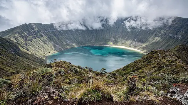
A crater lake with nothing built around it
Lagoa do Fogo sits in the middle of São Miguel, inside the caldera of the Água de Pau volcano, roughly halfway between the north and south coasts and reachable in well under an hour from Ponta Delgada. Its name means “lake of fire,” a nod to the volcano rather than to anything currently active, and it is the highest and least touched of the island’s crater lakes.
Unlike Sete Cidades, which holds a working village and a network of viewpoints and cafés around its own caldera, Lagoa do Fogo has no settlement, no restaurant, and nothing to buy. It is protected as a nature reserve, and the island’s authorities have deliberately kept it that way: no café, no ticket office, no gift shop, no bins, and no toilets, at the main car park or anywhere along the trails down to the water.
That absence of infrastructure is the point of this page. Most guides to São Miguel’s lakes talk about the view first. Here the honest starting point is what is not there — because arriving expecting even a basic snack stand or a public toilet, the way you would at Sete Cidades’ Vista do Rei or at Caldeira Velha, sets people up to be caught out. Plan Lagoa do Fogo as a stop between other things, self-sufficient, on a day when your schedule can bend around the weather.
Why the cloud decides your visit, not the calendar
At roughly 575 metres above sea level, sitting in a bowl surrounded by higher ground, Lagoa do Fogo intercepts cloud that passes well clear of the coast. It is common to leave a sunny Ponta Delgada morning and drive into thick fog twenty minutes later, with visibility down to a few metres at the car park. It is equally common for the cloud to burn off by mid-morning and return by early afternoon, or never lift at all. There is no reliable pattern by season, time of day, or weather app that removes the uncertainty — locals watch the crater rim itself, not a forecast, to judge whether it is worth the drive.
This page will not promise you a clear lake. If a website, tour listing, or driver tells you with certainty that you will see the water, treat that as marketing rather than a forecast. The honest plan is to build in flexibility: visit Lagoa do Fogo as one stop on a longer loop rather than the single reason for a day, so that a wall of cloud costs you twenty minutes rather than the whole outing. Some visitors deliberately return a second time later in the same trip if the first attempt was clouded out, since the drive itself is short.
Getting there: the EN5-2A and when it closes
The main approach is the EN5-2A, a narrow mountain road that climbs from the south side of the island up through pasture and scrub to the crater rim, with a car park and the principal viewpoint near the top. It is a genuine mountain road — tight bends, no barriers in places, and long drops on one side — and it is closed by the regional authorities outright in strong wind, heavy fog, or after storm damage, sometimes on short notice and without much warning posted in advance. Closures are more frequent from late autumn through winter, but a sudden squall can shut the road on an otherwise fine summer afternoon too.
Before setting out, check current road status rather than assuming access, particularly outside the June-to-September stretch. If you are relying on a rental car, see our notes on renting a car on São Miguel and on driving on São Miguel more generally — both cover the kind of narrow, exposed roads Lagoa do Fogo’s access road represents. A standard rental car is capable of the drive when the road is open; you do not need a 4x4 to reach the car park and viewpoints.
What you’ll actually find on site (and what you won’t)
At the top, the road ends at a small unpaved car park and a low stone viewpoint wall looking down into the crater. That is essentially the extent of the “infrastructure”: no attendant, no barrier gate, no signage beyond basic trail markers, and no facilities of any kind. There is no shop for water, no vending machine, no café terrace, and no public toilet — not a rustic one, not a paid one, nothing. Whatever you plan to eat or drink during your visit has to already be in the car.
This matters more here than at almost anywhere else covered on this site. Furnas, Sete Cidades, and Caldeira Velha all combine a natural site with somewhere to sit down and eat nearby; Lagoa do Fogo deliberately does not. Pack a proper picnic or snacks if you plan to spend any real time here, bring more water than you think you need, and use a bathroom before you leave your base for the morning. If you are coming from the north side — after visiting Ribeira Grande or the Gorreana tea plantation — or from Capelas further along the coast, the nearest cafés and toilets are back down at those towns, not anywhere near the crater.
Walking and hiking options
For visitors who only want the outlook, the walk from the car park to the main viewpoint wall takes five to ten minutes on a level path, and that alone is enough for most people who are combining Lagoa do Fogo with other stops in a single day. For those who want more, an unpaved trail drops from the rim down into the caldera to the lakeshore itself — a genuine hike rather than a stroll, with a real change in elevation, loose surfaces in places, and roughly two to three hours needed for the round trip at a comfortable pace. There is no shortcut version of this walk: once you start down, the only way back up is on foot, so treat it as a proper hike with the same seriousness you would give any unmarked mountain trail.
Good footwear is not optional here — trainers are workable in dry conditions but grip badly on wet volcanic soil, and the path has no railings or paved sections. Layers matter too: temperatures and wind at the rim can be markedly different from the coast, even on a day that felt warm in Ponta Delgada.
For a fuller route breakdown, see our dedicated notes on the Lagoa do Fogo hiking trail and on how the viewpoint looks when the cloud actually clears. If you are weighing this hike against the island’s other trails, our comparison of São Miguel’s best hikes puts it in context alongside routes around Nordeste and Sete Cidades.
If reaching the crater without worrying about the drive yourself appeals more, several operators run the access as part of a guided day. A jeep tour that handles the mountain road for you is a reasonable option on days when you would rather not be the one navigating switchbacks in patchy visibility, and it comes with a driver who tracks conditions daily rather than relying on a forecast checked the night before.
The viewpoints, when they’re clear
On a genuinely clear day — and it does happen, often enough to be worth trying for rather than dismissing — the reward is a near-symmetrical dark-blue lake filling most of the crater floor, ringed by steep green walls with almost no visible development anywhere in the frame. It is one of the few spots on São Miguel where a photograph shows no roads, no buildings, and no people, just water and volcanic slope. Early morning, before the day’s cloud has had time to build up the flanks of the massif, tends to give the best odds, though there is no guarantee attached to any hour.
Photographers who make this a priority sometimes plan a full-island loop with Lagoa do Fogo as an early stop precisely so a clouded-out attempt does not derail the rest of the day — our four-day full-island itinerary builds in that kind of flexibility. For a wider view of how the island’s weather actually behaves hour to hour, our general São Miguel weather guide is worth reading before you fix any single day around a view.
What Lagoa do Fogo is not
It is worth being direct about what this page does not cover, because the three sites sitting on the same volcanic system are easy to conflate. Lagoa do Fogo is not Sete Cidades: that site, in the island’s west, is a village built inside its own separate caldera, with twin lakes, several developed viewpoints, cafés, and accommodation, and it deserves its own visit rather than a combined half-hour with this one.
Lagoa do Fogo is also not Caldeira Velha: that is a thermal waterfall and bathing pool on the north slope of the same Água de Pau massif, with paid entry, changing facilities, and warm water you can actually get into — none of which exists here. If a thermal soak or a lakeside café terrace is what you are after, those two destinations deliver it; Lagoa do Fogo does not try to.
What Lagoa do Fogo offers instead is scale and quiet: a protected wild space at the island’s high point, without the crowds, souvenir stalls, or paved promenades of its neighbours. That is a deliberate trade-off, not an oversight, and it is the reason the reserve has stayed free of the development seen elsewhere on the island.
Planning your visit: what to bring, what to book ahead
Because there is genuinely nothing to buy on site, planning here means packing rather than booking. Fuel up before you leave — fuel stations thin out once you’re away from the main towns — and carry water, food, sun protection, and a waterproof layer regardless of what the coast looks like when you set off. If you intend to walk down to the lake, add proper footwear and allow a half-day rather than a quick detour. Check the access road’s status the same morning if you can, since conditions posted the night before can be out of date by the time you arrive.
For visitors who would rather not self-drive the mountain road at all, a few structured options exist. A half-day trip up to the crater rim suits anyone who wants the viewpoint and the drive handled without renting a car for the day, while a guided walk down to the lakeshore is worth considering if you want the full hike with a local guide who can read the cloud and adjust the route on the day.
Those who want to fold Lagoa do Fogo into a bigger day on the mountain can look at a full-day hike that combines the crater with nearby trails, which spreads the uncertainty of the weather over more hours and more terrain rather than a single quick stop.
Whichever way you approach it — self-drive, guided jeep, or on foot from the rim — go in accepting that the crater might be in the open air one moment and gone the next. That unpredictability, and the total absence of anything built to soften it, is what makes Lagoa do Fogo feel different from almost every other stop on this island.
Lagoa do Fogo FAQ: visiting São Miguel’s crater lake
Is there a café, restaurant, or shop at Lagoa do Fogo?
No. Lagoa do Fogo is a nature reserve with no built infrastructure at all — no café, no kiosk, no vending machine, and no ticket office. Bring water and food before you leave Ponta Delgada, Ribeira Grande, or wherever you are staying.
Will I definitely see the lake if I drive up?
No page can promise that, and neither can we. The crater sits inside cloud on a large share of days, sometimes for hours, sometimes all day, and the weather can flip in the time it takes to park. Treat a clear view as a bonus, not the plan.
Is the access road always open?
No. The EN5-2A that climbs to the main viewpoint and car park is closed by the local authorities in strong wind, heavy fog, or after storm damage, sometimes with little notice. Check conditions the same morning rather than assuming the road will be open.
How long does the walk down to the lakeshore take?
From the upper car park, reaching the water and coming back is roughly two to three hours on foot, on an unpaved trail with a real change in elevation. The viewpoints near the car park need only a five to ten minute walk if you just want the outlook.
Can I swim in Lagoa do Fogo?
Swimming is not set up or encouraged here the way it is at some other Azorean lakes; there are no facilities, no supervision, and the water and access paths can be difficult. Treat this as a hiking and viewpoint destination, not a swimming spot.
Is Lagoa do Fogo the same place as Sete Cidades or Caldeira Velha?
No. All three sit on the same volcanic system but are separate destinations on different sides of the island’s high ground: Sete Cidades is a village inside its own caldera with twin lakes in the west, and Caldeira Velha is a thermal waterfall and bathing pool on the north slope. Lagoa do Fogo is the undeveloped crater lake in between.
Do I need a 4x4 to reach Lagoa do Fogo?
A standard rental car reaches the main car park and viewpoints when the road is open — a 4x4 is not required for that. Jeep and buggy tours exist mainly for convenience, commentary, and reaching the reserve without worrying about closures yourself, not because ordinary cars cannot manage the tarmac.
What should I pack since nothing is sold on site?
Water, snacks or a packed lunch, a waterproof and windproof layer regardless of the forecast, sturdy shoes if you plan to walk down to the lake, and a full tank of fuel, since there is nothing to buy anywhere near the reserve.