The Best Hikes on São Miguel, Compared
Which hike should I choose on São Miguel?
For an easy, near-certain view, walk the Sete Cidades caldera rim. For a real chance at the endemic priolo bird, go into the Serra da Tronqueira forest in the east. For a dramatic crater lake with zero facilities and no view guarantee, hike into Lagoa do Fogo. Nordeste's coastal trails and the short Caldeira Velha walk suit anyone wanting waterfalls and thermal water without a full day of walking.
São Miguel has no single “best” trail — it has half a dozen very different ones, scattered across a farmed, volcanic island where the weather on one side can have nothing to do with the weather on the other. The right hike depends less on fitness than on what you actually want: a guaranteed view, a rare bird, a waterfall, or simply a walk that fits into an afternoon already booked with something else. This guide lines up the island’s main hiking options side by side, with honest notes on what each one delivers and what it can’t.
Matching the trail to the hiker
Before the detail, a working summary. Difficulty here means underfoot conditions and total walking time, not technical climbing — nothing on this list needs ropes or scrambling.
| Trail | Typical length | Difficulty | What it’s for | Facilities |
|---|---|---|---|---|
| Sete Cidades caldera rim | 2-4 hours (partial) | Easy-moderate | The classic twin-lake view | Village cafés at the caldera floor |
| Lagoa do Fogo | 3-5 hours round trip | Moderate | A crater lake, if the cloud lifts | None at all |
| Serra da Tronqueira (priolo trail) | Half to full day | Moderate | A chance at the endemic priolo | None on the trail |
| Salto do Prego, Faial da Terra | 2-3 hours round trip | Easy-moderate | A waterfall walk | Café in Faial da Terra |
| Ribeira dos Caldeirões, Nordeste | 1-2 hours | Easy | Waterfalls in a managed park | Car park, picnic tables |
| Caldeira Velha short walk | Under an hour | Easy | Thermal waterfall and pools | Ticket office, changing area |
| Pico da Vara approach | Full day | Moderate-strenuous | The island’s summit at 1,103 m | None |
Full details on each are in the linked trail guides below; the rest of this page explains why the choices differ so much from one end of the island to the other.
Serra da Tronqueira: the only trail with a real chance at the priolo
The Serra da Tronqueira, the laurel-forest massif in the island’s east, is the single place on São Miguel — and one of very few places on Earth — where the priolo survives. This small, russet-brown finch, also known as the Azores bullfinch, is among the rarest birds in Europe, and it lives nowhere else: not on the coast, not near Furnas, not anywhere a car can reach it. Seeing one means walking into the laurel forest itself, on foot, usually with a guide who knows the feeding areas and the season. Even then, nothing is guaranteed — this is a wild, elusive bird in dense native forest, not an aviary.
The trail through the Serra da Tronqueira rewards patience and quiet more than pace, and it pairs naturally with the wider Nordeste coastal day trip, since both sit in the same corner of the island. For the walk itself, see the Serra da Tronqueira priolo trail guide and the dedicated priolo and bullfinch guide, which covers timing and realistic expectations in more depth. The wider destination page for Serra da Tronqueira has the access details.
This is not a hike to add on impulse after lunch in Ponta Delgada — it sits at the eastern end of the island, well past Nordeste, and deserves its own half or full day.
Lagoa do Fogo: dramatic, and honestly conditional
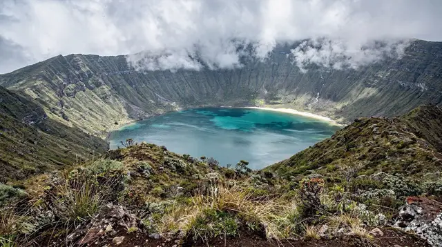
Lagoa do Fogo, the crater lake near the centre of the island, is often the single most photographed spot on São Miguel — when it’s visible. It is also the trail on this list where setting expectations correctly matters most. The reserve has no facilities whatsoever: no café, no ticket office, no bins, and no toilets anywhere near the rim or the descent to the water.
More importantly, the crater sits high enough that cloud settles over it constantly, independent of what the forecast for Ponta Delgada or Ribeira Grande says. It is entirely possible to arrive at the rim into thick fog after a clear drive up, and just as possible for that same cloud to lift an hour later. No page, including this one, can honestly promise a view from Lagoa do Fogo — only a chance at one, best improved by checking conditions on the day and building in flexibility rather than a fixed slot.
The hike down to the water and back is the main event for fitter walkers; those content with the rim view can do much less. Either way, start early, because the access road up from the south is sometimes closed outright in poor weather. The dedicated Lagoa do Fogo hiking trail guide and the crater lake overview cover the route in detail, and the viewpoint-when-clouds-clear guide is worth reading before you commit a whole morning to it. The Lagoa do Fogo destination page has access notes.
Walkers who would rather not gamble a hiking day on the weather, or who want local knowledge of which mornings are worth it, often book a guided option instead: a guided hike into the Lagoa do Fogo crater is built around exactly that judgment call, with a guide reading conditions before committing to the descent.
Sete Cidades: the reliable big view
Of everything on this list, the Sete Cidades caldera rim is the closest thing São Miguel has to a sure thing. The trail follows the rim above the twin lakes, with viewpoints that work in a wider range of weather than Lagoa do Fogo simply because the caldera sits lower. Walkers can do as little as a short section near a viewpoint or commit to a longer stretch of the rim; the caldera rim walk guide breaks down the options. It is also, notably, the one hike on this page where hydrangea hedgerows line much of the route in early summer, adding a photography angle that neither Lagoa do Fogo nor the Serra da Tronqueira offers in the same way.
For visitors who want the view without committing to a hike at all, a guided day covering Sete Cidades and the island’s west reaches the main viewpoints by vehicle, which suits anyone short on walking time or mixing the lakes into a wider day.
Nordeste’s coastal trails and waterfalls
The eastern tip of the island offers a different kind of hiking altogether: shorter, lower, and closer to the sea, with waterfalls rather than craters as the reward. The Ribeira dos Caldeirões trail is a managed park with a short, easy walk past a series of falls, well suited to anyone who wants scenery without a long approach.
From the village of Faial da Terra, the trail to Salto do Prego runs through a river valley to a tall waterfall and passes the restored hamlet of Sanguinho on the way — a walk short enough to combine with the wider Nordeste destination and its clifftop viewpoints in a single day. For those who’d rather see the same ground guided: a guided walk to the Sanguinho hamlet and Salto do Prego waterfall covers the same route with local context on the abandoned settlement along the way.
None of Nordeste’s trails climb as high as Lagoa do Fogo or reach as deep into forest as the Serra da Tronqueira, which is exactly why they’re a good fallback on a day when the interior is socked in cloud — the coast here often clears first.
Short walks near thermal country
Not every hike on São Miguel needs half a day. The short walk around Caldeira Velha, on the slope above Ribeira Grande, takes under an hour and ends at a thermal waterfall and pools rather than a summit — closer to a warm-up walk than a hike proper, and easy to slot in on a day built around the north coast or Furnas. It’s a sensible pairing for anyone whose main day is a wider loop rather than a dedicated hiking outing, and it needs neither hiking boots nor a full morning.
The high point: Pico da Vara
For hikers specifically chasing altitude, Pico da Vara — at 1,103 m the island’s high point — sits in the same eastern massif as the Serra da Tronqueira and the priolo forest. It’s a longer, more strenuous day than anything else on this list, better suited to experienced walkers comfortable with changeable mountain weather at short notice. The Pico da Vara summit guide has route notes; it pairs naturally with an early start from the same base used for the Serra da Tronqueira.
Weather, marking, and what to check before you go
Every trail on this page uses the Azorean PR trail-marking system, and the regional trails site is worth a check before setting out — paths close temporarily after landslides or storm damage, more often on the exposed coastal routes and in the wetter months. There are no snakes and no dangerous land animals anywhere on São Miguel; the real hazards on these trails are underfoot conditions on wet volcanic rock, cliff edges near coastal viewpoints, and fog rolling in at altitude rather than any wildlife. The island’s weather is genuinely local — rain over Lagoa do Fogo says nothing about conditions in Nordeste an hour later — so building a spare morning into a hiking-focused itinerary pays off more than chasing a specific forecast.
Anyone assembling several of these hikes into one trip, rather than picking a single outing, may find it easier to plan around a wider loop of the island. A guided full-island route, for example, a full-island jeep tour taking in the crater lakes and viewpoints covers much of the same ground as several of these trails in one day for anyone balancing walking time against a short stay.
For a longer visit built specifically around trails, the hiking Nordeste itinerary strings several of the routes above into a multi-day plan, and the general days-needed guide is useful for working out how much of this list actually fits your stay. Readers weighing personal safety on the trails more broadly can check the wildlife and hazards guide, and the blog notes on Lagoa do Fogo’s lack of facilities are worth a skim before that particular hike.
Choosing between the hikes: FAQ
What is the easiest hike on São Miguel?
The short walk around Caldeira Velha and the lower stretch of the Sete Cidades caldera rim are both manageable for most walkers, with gentle paths and a payoff close to the trailhead. Neither needs technical gear.
Can I see the priolo from the road or a viewpoint?
No. The Azores bullfinch survives only in the laurel forest of the Serra da Tronqueira, in the island’s east, and is not visible from a car window or a roadside stop. Seeing one at all means walking into the forest, ideally with a guide, and even then a sighting is not guaranteed.
Is the view from Lagoa do Fogo guaranteed?
No. Lagoa do Fogo sits high in the centre of the island and is frequently inside cloud, whatever the forecast says lower down. There is no facility at the crater rim to wait it out in either — no café, no shelter, no toilets — so a clear day is a bonus, never a promise.
Which hike is best for waterfalls?
The trail to Salto do Prego from Faial da Terra and the Ribeira dos Caldeirões park in Nordeste both centre on waterfalls, and both are shorter and lower-altitude than the Lagoa do Fogo or Serra da Tronqueira routes, so cloud is less of a factor.
Do I need a guide for these trails?
Not for the marked PR trails at Sete Cidades, Caldeira Velha, or Ribeira dos Caldeirões, which are walkable independently in normal conditions. A guide adds real value for the Serra da Tronqueira priolo trail and for Lagoa do Fogo, where local knowledge of weather windows and the terrain saves a wasted climb.
Are the trails marked and maintained?
Yes, with the Azorean PR numbering system, but several coastal and forest paths close temporarily after landslides or storm damage. Checking the regional trails site before setting out is worth the two minutes, especially after heavy rain.
Which hike suits a half day rather than a full day?
Caldeira Velha, the Sete Cidades caldera rim viewpoints, and the Salto do Prego walk from Faial da Terra all fit into a half day. Lagoa do Fogo and the Serra da Tronqueira forest reward a full day once driving and weather margins are counted in.
What should I pack for hiking on São Miguel?
Waterproof layers regardless of season, sturdy shoes with grip for wet volcanic rock, and food and water — there is nothing to buy at Lagoa do Fogo or along most of the Serra da Tronqueira. Fuel the car before heading to Nordeste, since stations thin out east of Ribeira Grande.
Comparison on GetYourGuide
Verified deep-linked GetYourGuide tours. Book through these links and we earn a small commission at no cost to you.
GetYourGuide does not provide a product photo for this activity — the image shows the meeting point, photographed by us.