Lagoa do Fogo: São Miguel's Crater Lake Reserve
What is Lagoa do Fogo and can you always see it?
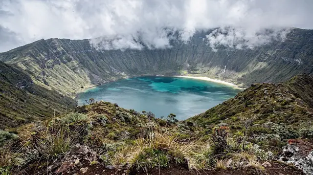
Lagoa do Fogo is a volcanic crater lake in the middle of São Miguel, protected as a nature reserve with no café, ticket office, or toilets. The lake sits high enough that it is frequently wrapped in cloud, and the access road can close for fog or wind, so a clear view is never guaranteed on any given day.
The Lake With No Village Around It
Every other big crater on São Miguel has been settled, roaded, and built up over the centuries: Sete Cidades has a village inside its caldera, Furnas has a spa town simmering over its fumaroles. Lagoa do Fogo, sitting almost exactly in the middle of the island, has none of that. There is no hamlet on its shore, no restaurant terrace looking down at the water, no gift shop at the top. What there is instead is a protected nature reserve, a lake the colour of pewter or bright blue depending on the light, and a road up that does not always let you finish the climb.
That absence of infrastructure is the whole character of the place, and it is also the reason a visit to Lagoa do Fogo needs to be planned differently from a stop in Sete Cidades or Furnas. This guide covers what the lake is, how it formed, why it is protected the way it is, and what actually determines whether you will see it on the day you go. It does not cover the descent on foot to the shoreline, which belongs to the Lagoa do Fogo hiking trail guide, and it does not cover organised 4x4 access, which is its own separate subject at the Lagoa do Fogo jeep tour guide.
How Lagoa do Fogo Was Formed
Lagoa do Fogo — literally “Lake of Fire” — occupies the summit caldera of the Água de Pau volcano, one of the three central volcanic systems that, together with the older shield to the west and the younger complex to the east, built up the island of São Miguel over the last few hundred thousand years.
Água de Pau has erupted repeatedly through the Holocene, most violently in a set of explosive eruptions that emptied part of its magma chamber and let the summit collapse inward, forming the caldera the lake now fills. The most recent confirmed eruption at Água de Pau dates to the 15th century, within living memory of the earliest Portuguese settlement of the island, which is a useful reminder that these are not extinct volcanoes on a geological timescale — they are dormant ones.
The result is a near-circular basin holding a body of fresh water with no permanent outlet stream reaching the sea, ringed by steep, densely vegetated walls that rise more than 200 metres above the lake surface at some points. Unlike the twin lakes of Sete Cidades, which sit at a lower altitude in a gentler, more open caldera that has long supported a village, farmland, and a paved road running down to the water’s edge, Lagoa do Fogo’s caldera is higher, steeper, and colder, which has kept it far less hospitable to settlement.
For the broader volcanic picture of how São Miguel’s craters relate to one another, see the island’s volcanic history overview, and for a plain explanation of how a caldera lake differs from the island’s lava tubes, see caldeiras versus lava tubes explained.
A Nature Reserve With Nothing Built On It
Lagoa do Fogo and the slopes around it form part of a protected nature reserve, one of the strictest conservation zones on São Miguel. The practical result for a visitor is simple and worth repeating clearly: there is no café at Lagoa do Fogo, no ticket office, no shop, and no public toilet. Nothing is sold there and nothing is collected there. Whatever water, snacks, or sun protection you need for the visit has to come with you from Ponta Delgada, Água de Pau, Vila Franca do Campo, or wherever you are staying, because there is nowhere at the site to buy them.
This is a deliberate outcome of the reserve’s status, not an oversight waiting to be fixed. The absence of buildings, parking infrastructure beyond a couple of simple pull-offs, and paved paths down to the shore is precisely what has kept the caldera walls covered in native and naturalised vegetation rather than holiday chalets. Compare that with the fully developed viewpoints and access roads around Sete Cidades, and the contrast tells you what kind of place this is: a working reserve first, and a sight to visit second.
The lack of facilities also means there is no one on site to tell you the road is closed, the weather has turned, or the light is fading. Whatever planning you do, you do it before you leave, not when you arrive.
Getting There: The EN5-2A and Why It Sometimes Closes
The main approach to Lagoa do Fogo’s viewpoints is the EN5-2A, a narrow secondary road that climbs from the south coast, near Água de Pau and the Ribeira Grande–Lagoa area, up over the shoulder of the volcano to car parks near the crater rim. It is a proper mountain road: tight bends, no barrier in places, and a surface that gets slick fast in rain. Driving on São Miguel in general means narrow lanes and sudden weather changes, and the EN5-2A is where those two facts matter most.
Two things close it, separately or together. The first is fog: cloud regularly sits directly over the summit caldera even on days that are bright and clear at sea level, and when visibility on the upper section drops too low, the regional roads authority can restrict or close the route rather than leave drivers navigating blind bends in zero visibility. The second is wind: the exposed upper stretch, with the caldera opening up to one side, catches gusts that are simply not a factor on the coast, and strong wind events — most common from autumn through winter but possible at any time of year — can also trigger a closure.
Neither closure is announced far in advance, and neither is something a website can promise around. If the EN5-2A is on your plan for the day, it is worth treating it as a “if the weather allows” stop rather than a fixed appointment, and having a lower-altitude alternative ready — a walk in Ribeira Grande, the thermal pools at Caldeira Velha, or a stretch of the south coast — in case the road is shut when you arrive.
When You’ll Actually See the Lake
This is the point worth being blunt about: nobody, including this guide, can tell you in advance whether Lagoa do Fogo will be visible on the day you visit. The caldera sits high enough and central enough on the island that it intersects the low cloud that regularly forms over São Miguel’s interior, and that cloud behaves independently of what the coast is doing. It is entirely normal to leave Ponta Delgada in bright sun, reach the viewpoint car park forty minutes later, and find the entire crater sitting inside a grey wall with visibility down to a few metres.
It is equally normal for the exact opposite to happen: fog on the coast, and a clear crater above it. The island’s weather changes hour by hour and side by side, and Lagoa do Fogo is one of the clearest places on São Miguel where that fact becomes unavoidable — see why the weather changes hour to hour on São Miguel for more on why no single forecast covers the whole island.
A few patterns help shift the odds, without ever guaranteeing anything. Mornings, particularly early ones before the day’s cloud has built up, tend to offer better odds than mid-afternoon. The drier months from June to September see the crater in cloud less often than the wetter months from November to March, though even in August a clear morning can cloud over completely by midday. None of this converts into a promise; it only converts into slightly better odds, and a visit should be built around flexibility rather than certainty. For a broader sense of what each season is actually like on São Miguel, the island’s month-by-month guide sets expectations before you commit dates.
If cloud does roll in while you are there, waiting twenty or thirty minutes at the viewpoint sometimes pays off, since the cloud over the caldera can lift and re-form within a single visit. It is also, frankly, sometimes a wasted half hour. Treat any Lagoa do Fogo stop as a bonus if it works out, not as the anchor of the day.
Best Viewpoints Without a Trail
For visitors who are not descending to the shoreline — that full walk down and back is covered separately in the Lagoa do Fogo hiking trail guide — the crater rim itself offers several roadside and short-walk viewpoints that need no more than the EN5-2A and a car park.
| Viewpoint | Approx. altitude | What you get | Effort |
|---|---|---|---|
| Miradouro do Pico da Barrosa | ~900 m | The classic wide view down over the full lake and both caldera walls | 2-minute walk from the car park |
| Southern rim pull-offs | ~750-850 m | Closer, lower-angle views toward the lake’s southern shore | Roadside, no walk |
| Northern approach viewpoint | ~800 m | A different angle from the Ribeira Grande side of the massif | Short walk from a small parking area |
None of these require hiking gear or a planned route; they are stops along or just off the EN5-2A. For a more structured photography-focused route through this and other island viewpoints, see the photography and viewpoints itinerary.
Wildlife and the Reserve Rules
The caldera walls around Lagoa do Fogo carry some of the best-preserved native vegetation left on São Miguel, including remnants of the laurel forest that once covered much of the island’s interior before farming and grazing spread across the lowlands. That vegetation is exactly why the reserve rules exist: staying on the marked viewpoint areas and car parks, not lighting fires, not leaving litter (there is no bin to leave it in, and no one to collect it), and not letting the lack of a fence tempt you onto unstable crater-wall ground protects both the plant cover and, in practice, visitors themselves, since the caldera walls are steep and the ground can be loose.
The reserve is not typically where visitors go looking for the island’s rarest bird, the priolo, which is confined to the laurel forest of the Serra da Tronqueira in the island’s east — that is a separate destination with its own guide. What Lagoa do Fogo does offer is a sense of São Miguel before roads and pasture reshaped most of the island: a steep, forested crater with a lake at the bottom of it, largely left alone.
Planning a Realistic Visit
A visit to Lagoa do Fogo works best as a flexible stop built into a longer loop rather than a dedicated half-day trip on its own, precisely because the payoff is never certain. Most visitors combine it with a route that already passes near the south coast or the centre of the island — a loop that might also take in Vila Franca do Campo or Caloura — so that a closed road or a cloud-filled crater costs twenty minutes of detour rather than an entire day’s plan.
What to bring, given the total absence of facilities on site: water, since none is sold there; a layer warmer than whatever the coast requires, since the crater rim sits several hundred metres higher and is noticeably colder and windier than Ponta Delgada; and a full tank or charge before setting out, since there is no fuel available anywhere near the reserve. Checking the current road status before driving up is worth the two minutes it takes, particularly outside the June-to-September window when closures are more frequent.
For visitors who would rather have a guide handle the driving, the timing, and the fallback plan if the crater is socked in, several small-group and private tours run from Ponta Delgada that combine Lagoa do Fogo with Sete Cidades or the wider volcanic highlands in a single day. The Lakes Highlands tour taking in both Sete Cidades and Lagoa do Fogo covers the island’s two most photographed crater landscapes in one outing, with a driver who already knows whether the upper road is open that morning.
A smaller, more personal option is the guided visit combining Sete Cidades and Lagoa do Fogo, and for visitors who want the volcanic geology explained on site rather than picked up from a guidebook, the biologist-led tour covering the volcano’s geology and hot springs puts a specialist in the car with you.
How Lagoa do Fogo Fits Into a Wider Route
Because there is genuinely so little to do at Lagoa do Fogo beyond looking at it — no museum, no restaurant, no marked walk from the roadside viewpoints — it rarely anchors a full day on its own. It works better as one stop within a longer island loop or as an add-on to a day already centred on Sete Cidades or the south coast. Visitors basing their planning around the best time to visit São Miguel should note that Lagoa do Fogo’s odds of a clear view track the island’s general seasonal pattern, but never move to certainty at any point in the year.
None of this makes Lagoa do Fogo a lesser stop than the island’s more developed craters — if anything, the absence of a village, a car park kiosk, or a paved promenade is the reason it still looks the way it did before São Miguel had roads at all. It simply asks visitors to hold the visit loosely: bring warm layers, check the road, and treat a clear view of the lake as a genuine piece of luck rather than a line item on a schedule.
Volcanoes & Craters on GetYourGuide
Verified deep-linked GetYourGuide tours. Book through these links and we earn a small commission at no cost to you.
GetYourGuide does not provide a product photo for this activity — the image shows the meeting point, photographed by us.