Lagoa do Fogo Viewpoint: When the Clouds Clear
Will I definitely see the lake at Lagoa do Fogo?
No. Lagoa do Fogo is an unstaffed nature reserve with no facilities, and the crater is often sitting inside cloud. The access road can also close in fog or strong wind, so treat a clear view as a bonus, never a booking.
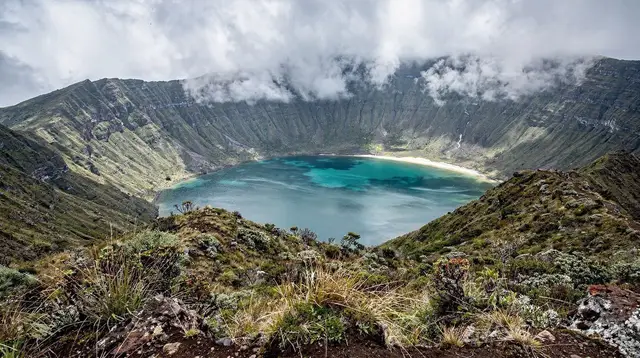
Every photo you have seen of Lagoa do Fogo — the sapphire crater lake ringed by green slopes, shot from above in flat sunlight — was taken on a day the cloud happened to lift. Nobody photographs the other kind of day, when the same viewpoint looks out onto a wall of grey with the wind pulling at the guardrail. Both days are normal here. This page is about planning for the second one so the first one, if it comes, is a bonus rather than the whole point of the trip.
What Lagoa do Fogo actually is
Lagoa do Fogo sits inside a volcanic caldera roughly in the middle of São Miguel, between the north coast and the south. It is a nature reserve, not a resort attraction, and that distinction shapes everything else on this page. There is no visitor centre, no staff on site, and no infrastructure beyond a road, a couple of unpaved pull-ins, a low wall at the main lookout, and the trails that drop down toward the water. The destination page for Lagoa do Fogo covers the caldera’s geology and access roads in more depth; this one is specifically about the viewpoint experience and the weather that makes or breaks it.
Because the reserve has no facilities, it also has nobody checking the weather on your behalf. The lookout is unstaffed, the road has no barrier operator posting live updates for tourists, and the difference between a clear lake and a wall of fog can be a matter of the hour you arrive, not the season you chose.
The table that matters more than any photo
Before the road, before the timing advice, it helps to be precise about what is and is not up there, because expectations set by other destinations do not transfer here.
| At Lagoa do Fogo | Not at Lagoa do Fogo |
|---|---|
| A road up to the ridge and a couple of pull-ins | A car park with an attendant |
| A low wall and open ground at the main lookout | A café, snack van, or restaurant |
| Marked trails down toward the shore | A ticket booth or entry fee |
| Wind, cloud, and open sky, in some order | Public toilets |
| A protected reserve with no lighting or signage lit at night | Phone signal you can rely on |
If a page, a photo caption, or a driver promises you a guaranteed clear view, a coffee stand, or a bathroom break at the top, that promise does not match the place. Plan the day so none of those absences becomes a problem.
Why the cloud comes and goes
Lagoa do Fogo sits at enough altitude, and close enough to where moist Atlantic air rises over the island’s central massif, that cloud forms there more readily than it does at sea level in Ponta Delgada or Vila Franca do Campo. The same weather system that leaves the coast dry and bright can be sitting directly on top of the crater. It also moves: a viewpoint that is socked in at ten in the morning can be clear by eleven, and vice versa.
This is the same island-scale pattern covered on the São Miguel weather guide and in the note on how conditions differ side by side across the island — it can be raining in Furnas while Ponta Delgada stays dry, and the crater ridge plays by its own rules again.
There is no reliable app or website that forecasts cloud specifically at Lagoa do Fogo hours in advance. The most useful thing you can do is look at the ridge itself from lower ground — from the via rápida near Lagoa or Água de Pau, from Ribeira Grande, or from a high point in Ponta Delgada — before committing to the drive up. If the top of the massif is visibly wrapped in cloud from a distance, it is very likely to still be wrapped in cloud when you arrive.
Some general tendencies are worth knowing, without treating any of them as a guarantee:
- Mornings, especially early ones, are often clearer than mid-afternoon, when cloud has had more hours to build over the interior.
- Wind can clear cloud fast, but strong wind is also one of the two reasons the road gets closed.
- The month-by-month guide and the best-time-to-visit overview both note that no month is immune — the crater catches cloud in July as well as January, just with different odds attached.
The road, and why it sometimes isn’t open
The access road climbs onto an exposed section of the island’s central ridge, with the Lagoa do Fogo destination page covering its route in detail. In fog with very low visibility, or in genuinely strong wind, the regional authorities can and do close it — sometimes for a few hours, sometimes for most of a day. There is no published schedule for these closures; they respond to the conditions on that particular day.
Practically, this means:
- Build Lagoa do Fogo into a day that has a plan B, rather than a day built entirely around it. Several of the full-island and multi-day itineraries route past the crater without depending on a single viewpoint stop working out.
- If you are driving yourself, check the road’s status before you commit to the detour — locally, hotel staff or a car rental desk usually know the same morning if it is closed.
- If the road is closed or the lake is in cloud, the sensible move is to come back another day rather than wait it out at the top, since there is nowhere to wait comfortably — no shelter, no seating, no coffee.
The general driving conditions on the island’s back roads, including the passes that can be affected by fog, are covered in the guide to driving on São Miguel and the car rental guide, both worth reading before a self-drive day that includes the crater.
Two ways to see it: the viewpoint and the hike
Most visitors experience Lagoa do Fogo from one of the roadside lookouts, where the lake sits several hundred metres below in the caldera bowl. This is a short stop — pull in, walk to the wall, look, walk back — and it asks nothing of your fitness or your schedule beyond the drive itself and whatever time you spend waiting for a gap in the cloud, if there is one to wait for.
The other way is to walk down toward the shore on the marked trails that drop from the rim into the crater. This is a real hike, not an extension of the car park: uneven volcanic ground, a genuine change in elevation, and weather that can shift while you are down inside the bowl and out of sight of the road. The Lagoa do Fogo hiking trail guide and the broader comparison of São Miguel’s best hikes set out route options, timing, and what to bring. If cloud rolls in while you are at the shore, visibility on the way back up can drop fast, which is one more reason this is not a spontaneous detour in poor footwear.
For a fuller sense of what a half-day or full-day visit involves start to finish, the Lagoa do Fogo day trip guide and the crater lake guide go into the geology, the trail network, and realistic timings in more detail than fits here.
Photographing it without banking on the shot
Because the lake photographs so well when it is visible, it is tempting to build a whole day’s plan around getting that one frame. A more useful approach for anyone bringing a camera:
- Treat the crater as a stop within a bigger loop, not a destination on its own, so a wasted trip up the ridge does not sink the day.
- Shoot the approach and the caldera slopes even when the lake itself is obscured — cloud moving through a crater has its own character, and not every good photo here is the clear-day postcard shot.
- Keep gear dry and protected; the same conditions that clear cloud (wind, sudden showers) are hard on cameras left uncovered at an exposed lookout.
- If photography is the priority for the day and the crater is closed in, the viewpoints at Nordeste or a sunset spot elsewhere on the island are lower-altitude alternatives less prone to the same cloud pattern.
This is not the island’s only volcanic-lake viewpoint story, either — the twin lakes at Sete Cidades sit in a different caldera in the west, with their own light and their own hydrangea season, and are covered separately in the Sete Cidades viewpoints and hydrangeas photo guide rather than here.
Going with a guide instead of gambling the drive
Because nobody controls the weather on the ridge, some visitors prefer to hand the timing decision to someone who checks conditions daily rather than build a self-drive day around a forecast. A few options built around the crater:
A half-day outing focused specifically on the crater lake suits a shorter visit or a base in Ponta Delgada, with a driver who can read the day’s conditions before committing to the ridge road.
For anyone who wants the walk down toward the shore rather than just the roadside view, a full-day guided hike into the caldera covers the descent, the trail conditions, and the return climb with a guide who knows the terrain in poor visibility as well as good.
A half-day jeep route up to the crater is a middle option — less walking than the hike, more flexibility on timing than a fixed self-drive itinerary, and a driver who can reroute if the road is closed that day.
None of these can promise a clear lake either — no operator controls the weather — but they remove the road-status guesswork and the wasted drive if conditions turn.
What this page deliberately leaves out
This guide is about the viewpoint and the weather gamble specifically. It does not cover the twin lakes and viewpoints of Sete Cidades, which sit in a separate caldera in the island’s west and have their own dedicated coverage in the Sete Cidades and hydrangeas photo guide. It also does not repeat the fuller trail-by-trail breakdown in the hiking trail guide, or the geology and history covered on the destination page and the crater lake guide.
And it is worth repeating the one thing this page keeps coming back to: São Miguel overall is a farmed, inhabited island rather than untouched wilderness, but Lagoa do Fogo is the one corner of it left almost entirely without infrastructure — which is exactly why it rewards planning rather than assumptions.
Lagoa do Fogo viewpoint, questions answered
Is there a café or restaurant at the Lagoa do Fogo viewpoint?
No. There is no café, snack van, restaurant, or any food service at either main viewpoint or at the trailheads. Bring water and snacks from Ponta Delgada, Ribeira Grande, or Vila Franca do Campo before you drive up.
Are there toilets at Lagoa do Fogo?
There are no public toilets at the viewpoints or along the crater road. Plan around this, particularly with children, and use facilities in the nearest towns before heading up.
Do I have to pay an entry fee to see Lagoa do Fogo?
No. There is no ticket booth, turnstile, or entry charge — it is a nature reserve, not an attraction with a gate. The only cost is getting there, whether by rental car, taxi, or a guided tour.
Why is the lake often hidden in cloud?
Lagoa do Fogo sits inside a volcanic caldera near the middle of São Miguel, at an altitude where moist Atlantic air condenses. Cloud can form and clear within the same hour, and locals check conditions rather than trust a forecast made the night before.
Can the road to Lagoa do Fogo be closed?
Yes. The access road climbs onto an exposed ridge and is sometimes closed by the regional authorities in heavy fog, strong wind, or after storm damage. There is no fixed schedule for this — it is a same-day, sometimes same-hour decision.
What is the best time of day to try for a clear view?
Many visitors have better luck early in the morning, before the day’s cloud has built up over the interior, though this is a tendency, not a rule. Checking conditions from Ponta Delgada or Ribeira Grande before the drive is more useful than picking a fixed hour.
Is Lagoa do Fogo the same as the lakes at Sete Cidades?
No. They are two separate calderas on opposite sides of the island. Lagoa do Fogo is the central crater lake covered here; the twin lakes of Lagoa Azul and Lagoa Verde belong to Sete Cidades in the west, covered in a separate guide.
Can I hike down to the lake shore?
Yes, on marked trails from the main viewpoints, but this is a proper hike on volcanic ground with weather that can change fast, not a stroll from a car park. Sturdy shoes and a plan for sudden fog are essential.
Photography on GetYourGuide
Verified deep-linked GetYourGuide tours. Book through these links and we earn a small commission at no cost to you.
GetYourGuide does not provide a product photo for this activity — the image shows the meeting point, photographed by us.