Lagoa do Fogo Day Trip: What to Expect
What should I expect on a day trip to Lagoa do Fogo?
Expect a crater lake with zero visitor infrastructure: no café, no ticket office, no bins, no toilets, just two roadside viewpoints. The access road, the EN5-2A, sometimes closes for fog or wind, and the caldera is frequently inside a cloud, so a clear view is never guaranteed on any given day.
A crater lake with nothing built around it
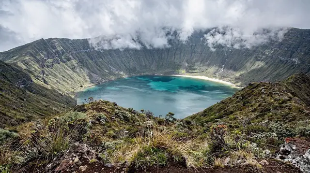
Lagoa do Fogo sits almost exactly in the middle of São Miguel, inside the caldera of the Água de Pau volcanic massif, and it is unlike every other headline stop on the island. There is no village on its shore, no café at the rim, no ticket office and no visitor centre. What exists is a narrow mountain road, two roadside viewpoints, a small amount of parking, and a nature reserve that is left almost entirely alone. That absence of infrastructure is not a gap someone forgot to fill in — it is the point of the place, and it is the single thing this page wants you to understand before you drive up.
Most people reach Lagoa do Fogo as one stop inside a longer loop, not as a destination in its own right. It pairs naturally with a crossing between Ribeira Grande on the north coast and the south coast near Água de Pau, or as a detour from a wider island circuit. Treat it that way: as a viewpoint you fold into a bigger day, with a plan B ready if the lake isn’t showing itself when you arrive.
What “no facilities” actually means on the ground
It’s worth being blunt about this, because it trips up more visitors than almost anything else on the island. At Lagoa do Fogo, there is:
- No café, kiosk or vending machine at either viewpoint
- No ticket office or entrance fee — access is free, but also unattended
- No public toilets
- No bins — whatever you bring up, you carry back down
- No gift shop, no visitor centre, no staffed information point
- Patchy or absent mobile signal in parts of the caldera
| At Lagoa do Fogo | Present? |
|---|---|
| Café or snack stand | No |
| Toilets | No |
| Ticket office / entry fee | No |
| Marked, staffed trails | No (unmarked reserve; see the separate hiking guide) |
| Paved viewpoint parking | Yes, small and informal |
| Mobile signal | Unreliable |
| Shade or shelter from wind and rain | Minimal |
This is deliberate. Lagoa do Fogo is a protected nature reserve, and the regional authorities have kept development off the crater rather than building the kind of visitor apparatus you’ll find at Sete Cidades or Furnas. If you need a bathroom, fuel, food or a phone signal, deal with it before you leave Ribeira Grande, Água de Pau or Ponta Delgada — not once you’re on the mountain.
The EN5-2A: a real mountain road, not a scenic drive with guardrails everywhere
The road up to Lagoa do Fogo, the EN5-2A, climbs from near sea level to somewhere over 900 metres in a fairly short distance, winding through pasture and then bare highland with no tree cover once you’re close to the top. It is narrow in places, has tight bends, and is genuinely exposed once you’re above the treeline — there’s nothing up there to break the wind.
That exposure is exactly why the road can close. The Azores’ regional roads authority shuts the EN5-2A, sometimes with little warning, when fog cuts visibility on the pass or when wind is judged strong enough to be dangerous, particularly for high-sided vehicles. Closures aren’t rare or exceptional; they’re a normal part of how this road is managed, and they can happen even on days that look fine lower down on the island. There is no way to promise, from a hotel room in Ponta Delgada the night before, that the road will be open the next morning.
Practically, that means:
- Build slack into your day — don’t schedule Lagoa do Fogo as the only thing between two fixed appointments.
- Have a fallback route or activity ready in case the pass is closed when you get there.
- If you’re driving yourself, check current conditions before committing to the climb; if you’re on an organised tour, the driver already tracks this and will reroute if needed.
- Never treat a clear morning in Ribeira Grande or Ponta Delgada as proof the summit road is open or clear — weather on this island changes by the valley, not just by the hour. Our general weather guide covers just how local these swings can be.
If you’re renting your own car for the island, our guides on driving on São Miguel and renting a car go into more detail on roads like this one.
Cloud is the default, not the exception
Even when the road itself is open, the caldera holding Lagoa do Fogo is one of the cloudiest spots on the island. Warm, moist Atlantic air rises against the massif and condenses right around the crater rim, which is part of why the interior stays as green as it does. The practical result is that a genuinely clear view of both lobes of the lake, gold-lit and photograph-ready, is something you get on some visits and not others — and there’s no reliable way to know in advance which kind of day you’ll land on.
Locals will tell you the early morning sometimes offers a better chance before afternoon cloud builds, but that’s a loose tendency, not a schedule you can bank on. It can be brilliant and clear at the coast while the crater sits in white-out, and the reverse happens too. Don’t let anyone — including this page — promise you a view. The honest plan is: go up hoping for the best, accept that fog is a real possible outcome, and have somewhere else worth visiting nearby if the lake is a wall of white when you arrive. Our companion piece on reading the caldera when clouds do or don’t clear walks through the patterns in more depth.
The two viewpoints
Most day-trip visits are built around two roadside miradouros on the crater rim, reached from opposite ends of the EN5-2A.
- The eastern viewpoint, closer to Água de Pau and the south coast, gives a wide angle down over both halves of the lake and is the more commonly photographed of the two.
- The northern approach, coming up from the Ribeira Grande side, offers a different angle as the road crests the rim, with the water appearing below the pasture and scrub in stages as you climb.
Neither has parking beyond a handful of pull-off spaces, and neither has any facility beyond a place to stop the car. If the crater is clear, ten to fifteen minutes at each is usually enough to take it in and get your photographs; if it’s socked in, you may find yourself looking at grey nothing and moving on within a couple of minutes.
What this page doesn’t cover — and where to find it
This guide is deliberately about the day-trip viewpoint experience: what’s there, what isn’t, and what the road and weather will realistically do to your plans. It does not cover walking around the lake itself, which is a separate undertaking with its own trail conditions, distances and timing — that’s covered in our Lagoa do Fogo hiking guide.
It also doesn’t get into off-road or 4x4 access into parts of the reserve that ordinary rental cars can’t reach; for that, see our Lagoa do Fogo jeep tour access guide. If you want the fuller picture of the crater’s geology and ecology rather than logistics, our crater lake guide is the better starting point.
Getting there: self-drive, organised tour, or part of a longer loop
Self-drive is the most flexible option if you already have a rental car, since it lets you decide on the day whether conditions look worth the climb, and to turn back or change your route if the pass is closed or clouded in. It also means you’re responsible for checking road status yourself rather than relying on someone else’s judgement.
Organised day tours take the uncertainty out of the driving and routing, since operators already track road closures and will build an alternative into the day if needed.
A number of full-island and highlands itineraries fold Lagoa do Fogo in alongside Sete Cidades or the north coast rather than visiting it alone — for example, a full-day trip such as the Lagoa do Fogo and Fenais da Luz day trip from Ponta Delgada pairs the crater with other highland and coastal stops, or a combined route like the Sete Cidades and Lagoa do Fogo day trip covers both of the island’s two best-known crater lakes in one outing.
If you’d rather set your own pace and timing around the weather on the day, a private trip to Lagoa do Fogo and nearby hot springs gives you a driver who can pivot the plan if the pass is closed.
As part of a longer loop, Lagoa do Fogo works well slotted into a broader island itinerary rather than a dedicated outing — our two-day classic itinerary and other planning guides show how it can sit between a north coast morning and a south coast afternoon. If you’re mapping out your first visit more broadly, how many days you need on São Miguel is a useful starting point, and a half day from Ponta Delgada to Sete Cidades or a Ponta Delgada city day trip can fill the rest of a day where Lagoa do Fogo turns out to be closed or clouded over.
A practical checklist
Because there is nothing to buy or rely on once you’re up there, what you bring matters more than at almost any other stop on the island.
| Bring | Why |
|---|---|
| Layers, including a windproof shell | The rim is exposed and noticeably colder and windier than the coast |
| Water and any snacks you’ll want | Nothing is sold anywhere near the viewpoints |
| A rubbish bag | No bins — you carry out what you carry in |
| A full fuel tank | Few fuel stations near the pass in either direction |
| A backup plan for the day | The road can close, and the lake can be in cloud, with no advance guarantee either way |
| Cash or a charged phone, but no reliance on signal | Coverage is patchy on the mountain itself |
If the crater is clouded out
Because a clear view is never guaranteed, it helps to know what else sits within easy reach on either side of the pass. Coming from the north, Ribeira Grande has cafés, shops and a proper town centre to fall back on. Coming from the south, Água de Pau and the coast road offer an easy detour.
If you’d rather plan around the uncertainty from the start, our rainy-day alternative itinerary is built for exactly this kind of shifting Azorean weather, and it’s worth reading alongside our broader note on how conditions change hour to hour across the island before you fix your plans too rigidly around any single viewpoint.
Lagoa do Fogo day trip: common questions
Is Lagoa do Fogo worth visiting if the forecast is bad?
It can still be worth the detour if you’re already crossing the island, but go in with low expectations. Lagoa do Fogo sits in a high-altitude caldera that generates and traps its own cloud, so a poor forecast for Ponta Delgada or Ribeira Grande doesn’t tell you what the lake will look like. Many visitors arrive to white-out and see nothing at all.
Are there toilets or a café at Lagoa do Fogo?
No. There is no café, no shop, no ticket office, no bins and no public toilets anywhere at the two viewpoints or the small parking areas. Use facilities in Ribeira Grande, Água de Pau or Ponta Delgada before you drive up, and carry out anything you bring in.
Why does the road to Lagoa do Fogo close?
The EN5-2A climbs to over 900 metres through terrain with no tree cover, so it is exposed to strong wind and to cloud that can cut visibility to a few metres. The regional authorities close it, sometimes at short notice, when conditions on the pass are judged unsafe, and it reopens once they clear.
Can I visit Lagoa do Fogo without a car?
There is no scheduled public bus to the viewpoints, so most visitors without a rental car join an organised day tour that includes Lagoa do Fogo, often paired with Sete Cidades or the north coast. A private driver is the other realistic option.
How long does a Lagoa do Fogo viewpoint visit take?
Seeing both main viewpoints and taking photos typically takes 30 to 60 minutes if the road is open and the lake is visible. Most people build it into a longer loop around the island rather than treating it as a standalone destination.
Is Lagoa do Fogo the same trip as Sete Cidades?
No. They are different craters on opposite sides of the island’s centre, roughly 40 to 50 minutes apart by road. Some tours combine both in one long day, but Sete Cidades has a village, cafés and marked trails inside its caldera, while Lagoa do Fogo has none of that.
What’s the best time of day to see the lake clearly?
There’s no reliable formula, but many locals say the earliest hours after sunrise sometimes catch a clear window before afternoon cloud builds over the interior. Treat that as a tendency, not a rule, and always have a backup plan for cloud.
Day Trips on GetYourGuide
Verified deep-linked GetYourGuide tours. Book through these links and we earn a small commission at no cost to you.
GetYourGuide does not provide a product photo for this activity — the image shows the meeting point, photographed by us.