An island, not an archipelago
São Miguel is the largest island of the Azores and the one most visitors mean when they say “the Azores” — but it is one island among nine, and this page is here to set the scale before the detail. It sits in the middle of the North Atlantic, about 1,400 km west of Lisbon, an autonomous region of Portugal with its own volcanic geography, its own weather, and its own rhythm.
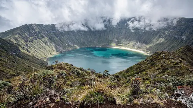
The island covers roughly 744 km², stretches about 65 km from Ponta Delgada in the west to Nordeste in the east, and narrows to between 8 and 15 km wide. Around 137,000 people live here — more than half the population of the entire Azores archipelago spread across a single island. Locals call it the Ilha Verde, the green island, and the name holds up: pasture, hedgerow, cloud and small towns cover almost every visible surface.
Everything on this site that goes deeper — Ponta Delgada, Sete Cidades, Furnas, Lagoa do Fogo, Nordeste, Ribeira Grande, Vila Franca do Campo — has its own page. This one exists to answer a different question: how big is this island really, how do you get here and move around, and what should you expect to see with your own eyes versus only on a map of the Azores.
Size, shape and the numbers that matter
São Miguel is an elongated volcanic island built from a chain of overlapping calderas and fissure eruptions, not a single cone. That shape explains almost everything about how a visit here is organised: the island reads naturally as a series of distinct volcanic zones strung along one long road rather than a single centre with day trips radiating out.
| Measure | Figure |
|---|---|
| Area | About 744 km² |
| Length | About 65 km, west to east |
| Width | 8 to 15 km |
| Population | Roughly 137,000 |
| Share of Azores population | Over half |
| Highest point | Pico da Vara, 1,103 m |
| Number of Azores islands | Nine, São Miguel the largest |
The island’s high point, Pico da Vara, rises in the Serra da Tronqueira above Nordeste in the far east — not visible from most of the coast, and reached by trail rather than road. Its laurel forest is the last home of the priolo, the Azores bullfinch, one of Europe’s rarest birds, found nowhere else on Earth and not a species you will see from a passing car.
Where São Miguel sits, and why there is no ferry
São Miguel sits roughly 1,400 km west of mainland Portugal, out in open Atlantic water with no other landmass in between. There is no ferry from the mainland — the only way in is by air, usually into João Paulo II airport (PDL) at Ponta Delgada. A Lisbon-Ponta Delgada flight takes about 2h15 to 2h30, and flights from Porto run similar times. Seasonal direct routes also connect Ponta Delgada to a handful of North American and European cities, which matters if you’re weighing São Miguel against a mainland Portugal trip on the same budget — the flight itself is a meaningful part of the planning, not an afterthought. For the full breakdown of routes and timing, see how to get to São Miguel.
One consequence of that distance and isolation: São Miguel runs on Azores time, UTC−1 in winter and UTC+0 in summer — one hour behind mainland Portugal all year. Flight boarding times, restaurant bookings and thermal-pool opening hours on this site are always given in Azores time; assuming mainland time is a reliable way to miss a flight.
Getting around: a rental car is the default
There is no train on São Miguel, and buses (Auto Viação Micaelense, Varela, Caetano) run on school and work timetables rather than sightseeing ones — useful for reaching towns, unreliable for chaining together viewpoints, waterfalls and thermal pools in a single day. A rental car is the practical default for most visitors, and it’s what makes the island’s shape — one long route rather than a single hub — actually workable.
The EN1-1A ring road circles the island; a faster dual-carriageway, the via rápida, links Ponta Delgada with Ribeira Grande and Lagoa along the north-central stretch. Away from those, roads narrow quickly, and the mountain passes up to Lagoa do Fogo and around Sete Cidades can close or sit inside cloud for hours at a time. For route planning and what the roads are actually like, see renting a car on São Miguel.
For a first structured route through the island, the four-day full-island itinerary and the more relaxed seven-day complete itinerary both build outward from this same shape: west, centre, north, east, south, in whatever order the weather allows.
The regions, briefly
This page won’t repeat what each area’s own page covers, but a short map is useful before diving in.
- Ponta Delgada, in the west-centre, is the island capital and by far the largest town, with the airport and cruise port a few minutes from its historic centre. It’s the natural first and last stop for almost every visit. Full detail: Ponta Delgada.
- Sete Cidades, in the far west, is a caldera village wrapped around twin lakes, reached by a dramatic descent from clifftop viewpoints. Full detail: Sete Cidades.
- The north coast, centred on Ribeira Grande, the island’s second town, mixes a surf beach, a thermal waterfall and two of Europe’s last tea plantations. Full detail: Ribeira Grande.
- Lagoa do Fogo, the crater lake at the island’s centre, is a nature reserve with no facilities and no guaranteed view — often in cloud, sometimes closed. Full detail: Lagoa do Fogo.
- Furnas, in the east, is a second, still-active caldera where meals are cooked underground and thermal springs are everywhere. Full detail: Furnas.
- Nordeste and the eastern tip hold the island’s wildest scenery: cliff-edge viewpoints, a laurel-forest reserve, and Pico da Vara itself. Full detail: Nordeste.
- The south coast, anchored by Vila Franca do Campo, the island’s original capital, adds a swimmable crater islet and a quieter, more agricultural stretch of coastline. Full detail: Vila Franca do Campo.
What São Miguel is, and isn’t, part of
São Miguel is the largest and most populated island of the Azores, and for many visitors it becomes a stand-in for the whole archipelago — which causes real planning mistakes. The Azores’ UNESCO-listed vineyards are on Pico, a different island reached by its own flight. The Azores’ UNESCO-listed old town, Angra do Heroísmo, is on Terceira, also a separate flight. The fajãs, the lava-flat coastal settlements the archipelago is known for in photographs, are a São Jorge feature. None of these are a day trip from São Miguel; reaching any of them means booking an inter-island flight or a long seasonal ferry, and none of the itineraries on this site assume otherwise.
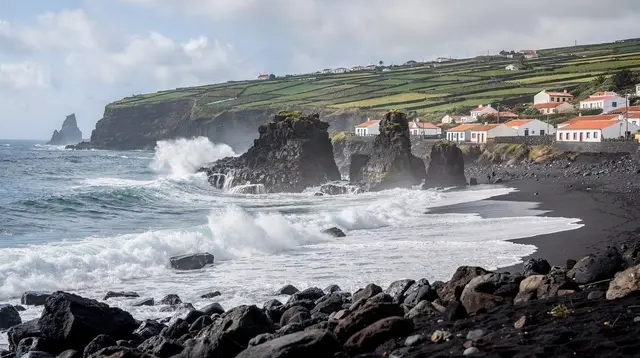
It’s also worth resetting two other expectations before arriving. São Miguel is not the Caribbean: the Atlantic here runs 17-24°C depending on season, the beaches are volcanic black sand, and sea conditions decide what boat trips and swimming spots are open on a given day, not the calendar. And despite the crater lakes and lava tubes, it is not wilderness — it’s a farmed, inhabited island of pasture, hedgerow and small towns, with cattle on the roads and villages between every viewpoint.
Money, language and the basics
The currency is the euro, and displayed prices already include VAT — the Azorean standard rate runs around 16%, notably lower than mainland Portugal’s 23%. Tipping is a round-up, roughly 5-10%, not the 15-20% expected in North America. Portuguese is the local language and English is widely spoken in tourism, though Azorean Portuguese sounds distinctly different from the mainland accent most learners study. The emergency number is 112, sockets are type C/F at 230V, and tap water is drinkable island-wide. Fuel stations thin out fast once you leave the main towns, so fill up before a long day around Nordeste. For a fuller cost breakdown by category, see São Miguel travel budget.
When to go
June to September is the driest, warmest run, with sea temperatures around 22-24°C and hydrangeas flowering from June through a July peak — also the busiest and most expensive stretch, when cars and Furnas restaurant tables need booking ahead. April to June and September to October offer the best balance: whale watching runs strongest from April to October, with blue, fin and sei whales passing on their spring migration roughly March to June, while sperm whales and dolphins are resident year-round.
November to March is mild but wet and windy, daytime temperatures around 14-17°C, sea near 17-18°C — thermal pools, tea plantations and museums all stay open, but boat trips cancel far more often. It’s an honest low season, not a dead one. Because the island is long and volcanic, weather varies by location as much as by month: it can be raining in Furnas while Ponta Delgada sits in sun, and no page on this site will promise a forecast beyond that. For a month-by-month breakdown, see best time to visit São Miguel.
Seeing the island in one go
Because São Miguel’s sights are spread the length of a long, narrow island rather than clustered near one town, a guided full-island day is a genuinely efficient way to get oriented before — or instead of — self-driving every route yourself. A jeep tour covering the west, centre and highlights of the whole island in a single day is a practical way to see the shape of São Miguel described above without four separate driving days.
For visitors basing themselves in Ponta Delgada with less time, a half-day tour through Sete Cidades and the western caldera country covers the single most photographed stretch of the island. And a full day built around the Furnas caldera, its underground-cooked lunch and thermal gardens is one of the more relaxed ways to understand how the island’s volcanic ground shapes daily life here, from cooking to bathing.
Cruise passengers with a single day ashore face a compressed version of the same planning problem this whole page addresses — too much island, too little time — and are usually better served by a route built specifically around a fixed return time; see shore excursions from Ponta Delgada for that version.
Planning from here
If you’re deciding whether São Miguel fits your trip at all, start with is São Miguel worth visiting and São Miguel vs Terceira if a second island is on the table. Once the destination is settled, how many days do you need on São Miguel and first-time guide to São Miguel turn the overview above into an actual plan, region by region, day by day.
Common questions about visiting São Miguel
How many days do you need on São Miguel?
Four days covers the highlights of the west, the centre and Ponta Delgada. A week lets you add the north coast, the far east around Nordeste, and slower days at the thermal pools without driving every day.
Do you need a rental car on São Miguel?
Yes, in practice. Buses run on school and work timetables, not sightseeing ones, and there is no train. A rental car is the default way to reach Sete Cidades, Lagoa do Fogo, Furnas and Nordeste on your own schedule.
Is there a ferry from mainland Portugal to São Miguel?
No. São Miguel sits about 1,400 km out in the Atlantic and is reached only by air, typically a 2h15-2h30 flight from Lisbon or Porto. Ferries exist between islands within the Azores in season, not from the mainland.
Is São Miguel the same as the Azores?
No. São Miguel is the largest and most populated of the nine Azores islands, but the archipelago’s other landmarks sit elsewhere: the UNESCO-listed vineyards are on Pico, the UNESCO old town is Angra do Heroísmo on Terceira, and the fajãs are on São Jorge. Reaching them from São Miguel means a flight or a long seasonal ferry.
What is São Miguel’s nickname and why?
Locals call it the Ilha Verde, the green island, for its pasture, hedgerow and near-constant cloud-fed greenery. It is a farmed and inhabited landscape rather than a wilderness, with cattle a routine sight on minor roads.
What is the highest point on São Miguel?
Pico da Vara, in the Serra da Tronqueira above Nordeste, at 1,103 m. It is also the last stronghold of the priolo, the Azores bullfinch, one of Europe’s rarest birds.
Is São Miguel safe to visit?
Yes. There are no snakes and no dangerous land animals on the island. The real hazards are ordinary ones: sea conditions at tidal and coastal spots, cliff-edge viewpoints, fast-changing fog on the mountain roads, and sun between showers.