A First-Time Guide to São Miguel, Azores
What should a first-time visitor to São Miguel know before booking anything?
São Miguel is a volcanic island in the Azores, an autonomous region of Portugal about 1,400 km out in the North Atlantic — it is not the Portuguese mainland and not the whole archipelago. It runs on Azores time, one hour behind Lisbon all year, and getting around means a rental car rather than trains, ski lifts, or resort shuttles.
Where São Miguel actually sits
Start with the map, because most of the confusion about São Miguel starts there. This is not a Mediterranean island and not a stop on a mainland Portugal road trip — it sits about 1,400 km west of Lisbon, alone in the North Atlantic, on its own hour and often its own weather. If you have never been to the Azores before, the single most useful thing to absorb before you book flights, cars, or tours is what kind of place you are actually flying to. Full background on the island itself lives on the São Miguel destination page; this page is about the assumptions worth checking before any of that gets booked.
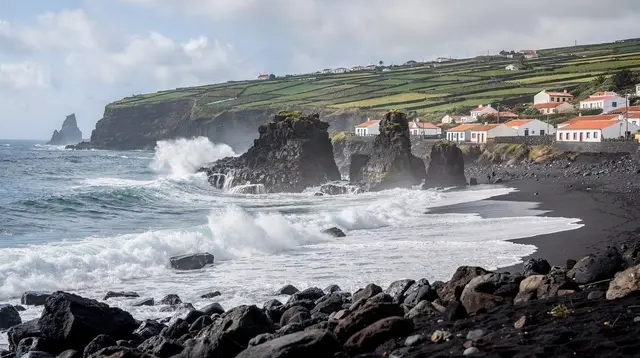
São Miguel is the largest of the nine islands that make up the Azores, an autonomous region of Portugal. It covers about 744 km², runs roughly 65 km end to end, and is home to around 137,000 people — over half of everyone who lives in the whole archipelago. Locals call it the Ilha Verde, the green island, and that’s the first correction to make to any mental image built on “Portuguese island in the Atlantic”: this is not a dry, sunburnt outcrop. It’s volcanic, damp, and covered in pasture, hedgerow, and small working towns, with cattle grazing right up to the road.
One island, not the whole archipelago
The single biggest first-timer mistake is treating “São Miguel” and “the Azores” as interchangeable. They aren’t. The Azores are nine separate islands spread across a wide stretch of ocean, each with its own character, and São Miguel — while the largest and most visited — is only one of them. The UNESCO-listed vineyards everyone has seen photos of are on Pico. The UNESCO old town with its colonial-era streets is Angra do Heroísmo, on Terceira. The dramatic coastal fajã settlements are on São Jorge. None of them are reachable as a day trip from here; each means a separate inter-island flight or a long seasonal ferry, and none of it happens by accident on a São Miguel itinerary.
That matters for planning because it’s easy to build expectations from generic “Azores” photos online and then feel shortchanged when São Miguel itself turns out to look different — lava tubes and crater lakes rather than terraced vineyards, thermal springs rather than a walled old town.
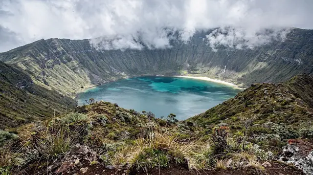
São Miguel has its own list of standout sights: the twin-lake caldera at Sete Cidades, the steaming ground and cozido pits of Furnas, the crater lake at Lagoa do Fogo, and the working capital of Ponta Delgada. If you want vineyards or fajãs, that’s a different island and a different trip — read São Miguel vs. Terceira if you’re weighing which island (or islands) actually match what you want to see.
Volcanic, not alpine
Because “Atlantic island with dramatic scenery” sometimes gets shorthanded into “mountains,” it’s worth being direct: São Miguel has no ski resort, no alpine passes, and nothing resembling the Alps. The island’s landscape is built from calderas, craters, and lava — its highest point, Pico da Vara in the Serra da Tronqueira massif, tops out at 1,103 m, which is a serious hiking summit but not a mountain range. The lookouts and viewpoints that dominate every photo of the island — Vista do Rei above the Sete Cidades caldera, Ponta do Sossego and Ponta da Madrugada on the Nordeste coast — are volcanic rims and sea cliffs, not mountain passes.
That volcanic geology is also what makes the island interesting rather than merely scenic: it’s why Furnas has fumaroles and a cozido cooked underground, why Caldeira Velha has a natural thermal waterfall, and why the interior road network narrows and climbs sharply in places, including the route up to Lagoa do Fogo, which has no facilities of any kind and is often sitting inside cloud. None of it is dangerous in the way a real mountain range can be, but it isn’t a gentle resort landscape either — bring the driving attention and footwear that a volcanic island deserves, not the ones packed for a beach resort.
One hour behind Lisbon, every day of the year
This trips up more visitors than anything else on this page: São Miguel does not share a time zone with mainland Portugal. Azores time runs UTC-1 in winter and UTC+0 in summer, which means it is always one hour behind Lisbon, in every season, with no exception. If you’re connecting through Lisbon or Porto, double-check every departure and arrival time against Azores time once you land — a flight, restaurant booking, or tour departure quoted casually in “Portugal time” by someone unfamiliar with the region is a real way to miss it.
The same logic applies to anything time-sensitive once you’re on the island. A cozido lunch booking in Furnas, a low-tide window at Ponta da Ferraria, or a whale-watching departure are all quoted in Azores time — treat any schedule you’re given as local until proven otherwise.
Money, tipping, and what things actually cost
São Miguel uses the euro, and prices you see are shown VAT included, with the Azorean standard rate running around 16%, noticeably lower than the mainland’s 23%. Tipping follows the same light-touch European pattern as the rest of Portugal — a round-up or roughly 5-10% for good service, not the 15-20% expected in North America. Card payment is standard in Ponta Delgada and in tourist-facing businesses; carrying some cash is still sensible for small village cafés and market stalls, including the Mercado da Graça in Ponta Delgada.
This page deliberately doesn’t attempt a full cost breakdown for a trip here — that’s covered properly on the dedicated São Miguel travel budget guide, and how long to actually stay is answered on how many days do you need on São Miguel. What’s worth knowing before you get that far is simply that prices are already tax-inclusive and tipping expectations are modest — useful context before either of those pages gets into numbers.
Getting there and getting around
There’s no ferry from mainland Portugal to São Miguel — the only way in is by air, into Ponta Delgada’s João Paulo II airport (PDL), about 2-3 km from the city centre. Lisbon to Ponta Delgada is roughly a 2h15-2h30 flight, Porto is similar, and there are seasonal direct routes from several North American and European cities. Full route and timing detail lives on how to get to São Miguel.
Once you’re on the island, the practical default is a rental car. Public buses exist — Auto Viação Micaelense, Varela, and Caetano run the main routes — but their timetables are built around school and commuting hours, not sightseeing, and there’s no train anywhere on the island.
The EN1-1A ring road circles São Miguel and a faster via rápida stretch links Ponta Delgada to Ribeira Grande and Lagoa, but away from those main corridors the roads narrow quickly, and the passes up to Lagoa do Fogo and Sete Cidades can close or vanish into fog with little warning. Renting a car on São Miguel covers what that actually looks like in practice, and if you’d rather not drive at all, guided tours vs. self-drive lays out the trade-off honestly.
For a first orientation loop that doesn’t require deciding on a car straight away, a guided option like an e-bike ride around the Sete Cidades caldera is a low-commitment way to see the island’s signature landscape without renting anything.
What the island is not
It helps to rule a few things out early, because they shape expectations more than any single sight does. São Miguel is not the Caribbean: the Atlantic here runs 17-24°C depending on season, the beaches are black volcanic sand rather than white coral sand, and the swell — not a marketing brochure — decides whether a boat trip or a swim spot is on for the day.
It is also not a wilderness in the empty, untouched sense: it’s a farmed, inhabited island of pasture, hedgerow, and small towns, with cattle sharing the roads, and its wild corners — like the laurel forest of the Serra da Tronqueira, home to the rare priolo bird — are the exception rather than the rule. And, as covered above, it is not a stand-in for “the Azores” as a whole; it’s one island among nine, with its own specific list of things to see and specific things it simply doesn’t have.
Weather is worth setting expectations on too. It changes hour by hour and can differ completely from one side of the island to the other — it’s entirely normal for Furnas to be under cloud while Ponta Delgada sits in sun. No page, including this one, can promise a forecast; plan for variability rather than a single verdict on “the weather” for your trip. For a fuller seasonal picture, see the São Miguel weather guide and best time to visit São Miguel.
A rough shape of the island, before you plan a route
Rather than repeat a day-by-day itinerary here — that’s what the itineraries section is for — it’s worth having a mental map of the island’s main areas before anything else. Ponta Delgada, the capital, sits on the south coast and holds the airport, the cruise port, and most accommodation.
West of it is the Sete Cidades caldera; north is Ribeira Grande and the tea and thermal country around Caldeira Velha; the geographic centre holds the crater lake of Lagoa do Fogo; east is Furnas and its cozido caldeiras; and the far eastern tip, around Nordeste, holds the island’s wildest coastal viewpoints and its highest point, Pico da Vara. The south coast beyond Ponta Delgada runs through Vila Franca do Campo — the island’s capital until a 1522 earthquake and landslide buried the original town — down to Ribeira Quente, which is where Furnas’ nearest beach actually is, over the ridge from the caldera itself.
A private day out that touches several of these zones in one go, guided rather than self-navigated, is a reasonable way to get oriented fast — something like a full-day guided tour covering Furnas and the Nordeste coast compresses a lot of that eastern geography into a single, well-paced day without the map-reading.
If you’d rather not plan the geography alone
For visitors who want the caldera landscapes explained on the ground rather than from a guidebook, a local-led tour of the Sete Cidades caldera puts the volcanic history of the island into context in the one place most people photograph first. Walkers who want the island’s terrain explained properly, rather than just viewed from a car window, might prefer a private hiking day with a local guide, which adapts to fitness level and weather in a way a fixed itinerary can’t.
None of these replace doing your own reading before you book — but they’re a reasonable way to let the island’s geography and volcanic logic sink in during the first day or two, before committing to a full self-drive plan for the rest of the trip. For the fuller case on whether the island suits what you’re after at all, read is São Miguel worth visiting, and for turning all of this into an actual day-by-day plan, move on to how to plan a São Miguel itinerary.
Quick reference for first-time planning
| Question | Short answer |
|---|---|
| Where is it? | Autonomous region of Portugal, ~1,400 km west of Lisbon, North Atlantic |
| Is it the whole Azores? | No — one of nine islands; Pico, Terceira, São Jorge are separate trips |
| Time zone | Azores time, one hour behind Lisbon all year |
| Currency | Euro, prices shown VAT included |
| How to arrive | Fly into Ponta Delgada (PDL) — no ferry from the mainland |
| Getting around | Rental car is the practical default; buses run on local timetables, not sightseeing ones |
| Mountains/skiing | None — volcanic terrain, high point Pico da Vara at 1,103 m |
| Language | Portuguese (Azorean accent); English widely used in tourism |
Frequently asked questions from first-time visitors to São Miguel
Is São Miguel part of mainland Portugal?
No. It’s the largest island of the Azores, an autonomous region of Portugal roughly 1,400 km west of Lisbon, with its own regional government and its own time zone.
Is São Miguel the same as “the Azores”?
No. The Azores are nine islands; São Miguel is the largest, but sights like Pico’s vineyards, Terceira’s old town, and São Jorge’s fajãs belong to other islands, not to São Miguel.
What time zone does São Miguel use?
Azores time — UTC-1 in winter, UTC+0 in summer — which is always one hour behind mainland Portugal, in every season.
Are there mountains or a ski resort on São Miguel?
No. The island is volcanic rather than alpine; its high point, Pico da Vara, is 1,103 m, and there’s no skiing anywhere in the Azores.
Do I need a passport or visa to visit São Miguel?
São Miguel is Portuguese territory in the EU and the Schengen area, so it follows the same entry rules as mainland Portugal — check current requirements for your nationality before flying.
What language is spoken, and is English enough?
Portuguese, with a distinct Azorean accent, is the local language. English is widely spoken across hotels, restaurants, and tours in the main visitor areas.
Is São Miguel safe for a first-time visitor?
Yes — there are no snakes or dangerous land animals. The genuine hazards are the ocean, cliff edges, fog on the high roads, and sun between showers.
Can I visit Pico’s vineyards or São Jorge’s fajãs from São Miguel as a day trip?
No. Both belong to other Azorean islands and require an inter-island flight or a long seasonal ferry — plan them as a separate leg of a wider Azores trip, not an add-on here.
Planning on GetYourGuide
Verified deep-linked GetYourGuide tours. Book through these links and we earn a small commission at no cost to you.
GetYourGuide does not provide a product photo for this activity — the image shows the meeting point, photographed by us.