The end of the island, and the start of the wild
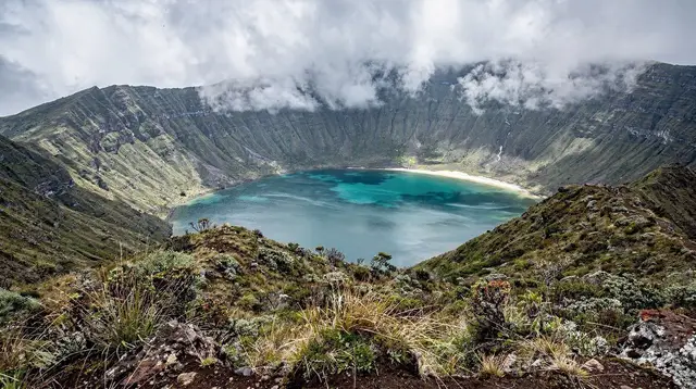
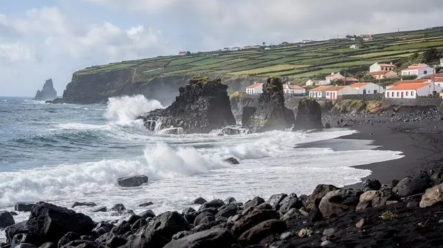
Drive far enough east on São Miguel and the island stops behaving like a place with a schedule. The towns thin out, the hedgerows close in, pasture gives way to forest, and the road starts following the shape of the land instead of cutting through it. This is Nordeste — not a single sight but a whole quarter of the island, the hilly, wind-scoured tip that sticks furthest into the Atlantic. It has no cozido pit, no thermal pool the size of a small lake, no crater village. What it has is a coastal road strung between clifftop viewpoints, a lighthouse that still works, a waterfall park built around old water mills, and — rising behind all of it — Pico da Vara, the island’s highest point.
Nordeste rewards people who like the drive itself, not just the stops along it. The EN1-1A brings you out from Povoação or Ribeira Grande, and from there a narrower road hugs the coast, climbing and dropping through short stretches of laurel and cryptomeria forest, past small dairy farms, with the sea appearing and disappearing between headlands. It is one of the few parts of the island where you can go an hour without passing a town of any size. That emptiness is the attraction as much as any single stop.
Two things are worth saying plainly before the details. First, this is a full corner of the island in its own right, best treated as a half-day loop at minimum, closer to a full day if you add a waterfall walk or a short hike. Second, several of Nordeste’s best-known names — Faial da Terra and its Salto do Prego waterfall, the Serra da Tronqueira forest and its priolo — have their own dedicated pages on this site, because they deserve more than a paragraph. What follows is the shape of the region: what’s on the road, what’s worth stopping for, and what to leave for another day.
Two viewpoints, one ridge road: Ponta do Sossego and Ponta da Madrugada
The two names most associated with Nordeste are viewpoints, and they sit on the same stretch of coastal road a few kilometres apart, so most people see both in the same visit.
Ponta do Sossego is the more manicured of the two: a small landscaped garden of hydrangea hedges and clipped paths set right on the cliff edge, with benches angled toward the sea. “Sossego” means calm, and on a still day the name fits — the garden gives the viewpoint a framed, deliberate feel, closer to a formal lookout than a wild clifftop.
Ponta da Madrugada, a short drive further on, is rawer. It sits higher and more exposed, with a longer, more open sweep of coastline visible below, and it’s the spot most associated with sunrise on this stretch of coast — “madrugada” means the small hours, or dawn. It’s also more exposed to wind and cloud than Sossego, so the two can have noticeably different weather within a few minutes’ drive of each other.
Neither viewpoint has more than basic facilities — a car park, maybe a bench or a small stall in season — so treat them as stops on a drive rather than destinations with their own infrastructure. Photographers in particular tend to linger at both, since the light changes fast on this coast and rarely looks the same twice.
Farol do Arnel, the lighthouse at the end of the road
Past the viewpoints, a narrow side road drops toward the sea and the Farol do Arnel, a working lighthouse perched on a headland at the island’s easternmost point. It’s one of the oldest lighthouses in the Azores, and it still marks the edge of São Miguel for ships passing well offshore. The building itself isn’t generally open to visitors, but the point it sits on is the draw: a stark, wind-blown headland with the cliffs of the north coast running away in one direction and open Atlantic in every other.
The access road to the lighthouse is steep and narrow, with limited turning space, so it’s not somewhere to arrive in a hurry or a large vehicle. Most visitors park before the final stretch and walk the last section. There’s no café, shop or facilities at the lighthouse itself — bring water if you’re planning to spend any time there, and expect wind even on a calm day inland.
Ribeira dos Caldeirões: a waterfall park, not a single fall
Inland and slightly south of the main coastal road, Ribeira dos Caldeirões is a small, well-kept park built around a stream that drops through a series of falls past the stone remains of old water mills. It’s easy to picture it as a single photogenic waterfall seen from a car park, but it’s really a short walking circuit — paths, footbridges and mill ruins threaded between more than one cascade, shaded by tree ferns and laurel.
Give it 30 to 60 minutes rather than a five-minute stop. The paths are easy underfoot and suit most fitness levels, which makes it one of the more accessible short walks on this side of the island, and a natural stop for families doing the coastal drive. There’s parking at the entrance and, in season, a small snack stand, but nothing beyond that, so it fits well as a midway break on a Nordeste day rather than a destination to build a whole trip around.
Pico da Vara: the island’s roof, and a forest you don’t just drive past
Behind Nordeste’s coastal villages, the land rises to Pico da Vara, 1,103 m, the highest point on São Miguel. It isn’t visible as a single obvious peak from most of the coastal road — it’s part of a wider ridge, the Serra da Tronqueira, cloaked in native laurel forest that survives here in one of its last strongholds on the island.
Two things about this forest deserve to be said clearly, because they’re easy to get wrong on a quick pass through Nordeste. First, reaching Pico da Vara’s summit or walking properly into the Serra da Tronqueira is a hike, not a roadside stop — marked trails climb from trailheads near the coast up into the reserve, and the summit is frequently wrapped in cloud regardless of how clear the coast looks below. Second, this forest is the only place on Earth where the priolo, the Azores bullfinch, still lives.
It’s one of Europe’s rarest birds, and it is not something you glimpse from a moving car on the coastal road or from a viewpoint car park — it lives deep in the laurel canopy and is found only by walking into the forest itself, usually on a guided trail, with patience and no promises. If seeing the priolo or reaching the summit is the goal, that’s a separate outing from the Nordeste coastal drive, worth planning as its own day. Full detail on both lives on their own pages: the Serra da Tronqueira and the dedicated priolo trail guide.
Nordeste town and the villages along the way
Nordeste town itself is small and unhurried, the kind of place with a church square, a handful of cafés and little through-traffic beyond people doing the coastal loop. It makes a sensible lunch stop or a base if you’re spending a night on this side of the island rather than doing it as a day trip from Ponta Delgada.
South of Nordeste, the road continues toward Povoação and eventually Furnas, passing through smaller settlements and past the turn-off for Faial da Terra, the trailhead village for the Salto do Prego waterfall and the restored hamlet of Sanguinho. That whole stretch — village, trail and waterfall — has its own dedicated page, since it’s really a separate outing from the Nordeste viewpoints loop: see the guide to Faial da Terra and the Salto do Prego hike for the details. If you’re building a longer eastern-side itinerary, Povoação sits between Nordeste and Furnas and is a natural link between the two.
Getting there, and why you fill the tank before you leave
Nordeste is reached by road only — there’s no other practical way in, and a rental car is by far the easiest way to see it, since bus timetables on this side of the island run on local schedules, not sightseeing ones (see the bus guide if you’re planning around them anyway). From Ponta Delgada, the fastest route follows the EN1-1A east through Ribeira Grande and Povoação before the road narrows onto the Nordeste coastal stretch; from Furnas, it’s a shorter, more direct link over the ridge.
One practical point matters more here than almost anywhere else on the island: fuel stations are genuinely rare once you’re past the main towns. There is no reliable place to fill up along the coastal road itself between the viewpoints, the lighthouse and Ribeira dos Caldeirões. Fill the tank in Ribeira Grande, Povoação or before you leave Ponta Delgada — running low partway around the Nordeste loop, on narrow roads with patchy phone signal, is an avoidable problem.
If you’re new to driving on the island’s narrow roads and passes, the driving guide is worth a read before you set out, and it’s also worth checking trail conditions in advance if you’re combining the drive with a walk — several coastal paths on this side of the island close after landslides (more on that in the note on PR trail markings and closures).
When to go
Nordeste can be visited at any time of year, but the experience changes with the season more than in most parts of the island, simply because it’s more exposed. Between April and October, days are longer, cloud tends to sit higher, and the viewpoints are more likely to deliver a clear sweep of coastline — this is also when the drive doubles well as a photography outing, with hydrangea hedges along the road from June onward.
Between November and March, the coastal road is still open and the waterfall park and lighthouse still work exactly the same way, but wind and rain are more frequent, and low cloud can sit over the higher viewpoints and the Tronqueira ridge for days at a stretch. None of that closes Nordeste — it just means checking the forecast for the east of the island specifically, since weather here can differ noticeably from Ponta Delgada or Furnas on the same day.
Tours and ways to see Nordeste
Most visitors see Nordeste by self-drive, stringing the viewpoints, the lighthouse and Ribeira dos Caldeirões into a loop from Ponta Delgada, Furnas or Povoação — the Nordeste coastal day trip guide lays out a sensible order for exactly that. If you’d rather not navigate the narrow roads yourself, or want a guide who can point out what’s easy to miss, a guided minibus tour through Nordeste’s viewpoints and waterfalls, with lunch included covers the same ground without the driving.
For a more active take on the region, a private 4x4 jeep tour into Nordeste’s back roads reaches viewpoints and tracks a standard rental car wouldn’t attempt, and a similar jeep route combining Nordeste’s coastal views with the edge of the Serra da Tronqueira pairs the two landscapes in a single day.
If Ribeira dos Caldeirões has you curious about the water itself rather than just the view of it, a canyoning route through the Ribeira dos Caldeirões falls is a guided, equipped way to descend the same stream the park’s paths only look down on — worth knowing about even if it’s a different kind of day out from the driving loop above.
Full detail on the coastal walking route between the falls and the mills is in the Ribeira dos Caldeirões trail guide, and photographers planning around the two viewpoints specifically should see the Ponta do Sossego and Ponta da Madrugada guide.
Hikers with a full day and good boots have two further options worth flagging separately, since both go well beyond the coastal road: the trail up Pico da Vara into the island’s high country, and the network of paths covered in the general Nordeste hiking guide for anyone building a walking-focused day around this part of the island.
Nearby, if you have more time
Nordeste sits at the end of the island’s main loop, which makes it a natural pairing with the places either side of it. To the south, Povoação and Furnas extend the same eastern-side day into caldera country; to the west along the same road, the drive back toward Ribeira Grande passes through some of the greenest farmland on the island.
If Nordeste’s forest and mountain draw you in, the Serra da Tronqueira page and its priolo trail are the next stop; if it’s the waterfall that stayed with you, Faial da Terra’s Salto do Prego is a short drive further south and worth a half-day of its own. None of these need to be rushed into the same afternoon as the coastal loop — Nordeste holds up perfectly well as a destination on its own.
Questions about visiting Nordeste
How far is Nordeste from Ponta Delgada, and how long does the drive take?
It’s roughly 45-50 km, about an hour by car on the EN1-1A before you reach the coastal road itself. Add extra time for stops: the viewpoints, the lighthouse turn-off and the waterfall park each ask for at least 20-30 minutes.
Can I see the priolo, the Azores bullfinch, at Nordeste?
Not from the road or a viewpoint. The priolo lives only in the laurel forest of the Serra da Tronqueira, above Nordeste, and is seen only by walking into that forest on foot, usually with a guide. Passing through Nordeste is not the same as visiting the bird’s habitat.
Are Ponta do Sossego and Ponta da Madrugada worth visiting on the same day?
Yes, and most visitors do both, since they sit on the same short stretch of coastal road a few kilometres apart. Each has a different angle on the cliffs and a different mood depending on the light, so seeing both takes little extra time.
Is there fuel available around Nordeste?
Stations are few once you leave the main towns. Fill the tank in Ponta Delgada, Ribeira Grande or Povoação before starting the circuit rather than counting on finding one along the coastal road or near the viewpoints.
Can you climb Pico da Vara?
Yes, on a marked trail, but it’s a proper hike into the Serra da Tronqueira reserve, not a roadside stop, and the summit is often in cloud. It’s the island’s highest point at 1,103 m and needs separate planning from a Nordeste driving day.
Is Ribeira dos Caldeirões one waterfall or several?
It’s a small park with more than one cascade and a walking path between old water mills, not a single drop-in photo stop. Most visitors spend 30-60 minutes walking the park rather than just viewing it from a car park.
Is the Nordeste coastal road difficult to drive?
It’s narrow, bendy and often quiet, which makes it enjoyable rather than stressful, but it is not a fast road. Fog and low cloud are common on the higher stretches, and some connecting side roads and trails close after landslides, so check conditions if you’re combining the drive with a hike.