Why I Check the PR Trail Site Before Every Hike Here
The trail I didn’t finish
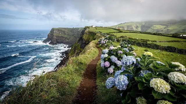
Three summers ago I drove out toward the eastern coast with a map, decent boots, and the kind of confidence that comes from seeing a painted waymark on a post. I’d read that a coastal PR trail linked two viewpoints, I could see the post, and I assumed that was the whole story. It wasn’t. Twenty minutes in, the path stopped at a barrier of loose rock and a faded sign I hadn’t seen at the start, propped sideways where the wind had knocked it. A section further along had slid into the sea the previous winter and never been rebuilt. I turned back, mildly annoyed, and only later understood that the annoyance was misplaced — the trail wasn’t broken, my assumption was.
That’s the habit this island has taught me: a waymark tells you a route exists, never that it’s currently open.
What the PR numbers actually are
Every official hiking route on São Miguel carries a PR code — pequena rota, the Azores’ regional short-trail system. You’ll see the posts on routes from the Sete Cidades caldera rim to the waterfall path at Ribeira dos Caldeirões to the coastal walk past Praia de Santa Bárbara. The numbering is useful precisely because it’s specific: it’s the reference you use to look a trail up, rather than a vague description of “the coastal path near the north side.” I now treat the code the way I’d treat a flight number — the thing I type into a search box before I trust the schedule.
The regional trails site lists status by PR number, and checking it has become as automatic as checking the weather. It takes less time than it took me to write this sentence, and it would have saved me that afternoon on the coast.
Why this island’s trails close the way they do
São Miguel is young, volcanic, and still settling. That’s true of the whole chain, but it matters more on foot than it does from a car window. The slopes above many coastal paths — especially through Nordeste and around Faial da Terra — are steep, saturated by rain most of the year, and built from layers of ash and loose rock rather than solid granite. After a heavy spell of weather, sections give way. Not dramatically, usually, and not often with anyone nearby to see it happen — a stretch of path simply isn’t there anymore by the time the next hiker reaches it.
This isn’t an abstract geological fact I picked up from a leaflet. It’s the same instability that buried an entire town. Vila Franca do Campo was the capital of the island until 1522, when an earthquake-triggered landslide swept down and buried much of it, forcing the seat of government to move to Ponta Delgada, where it has stayed ever since. That’s not a coastal footpath closing for a season — it’s the same terrain, at the scale of a town. When I stand on a viewpoint near Vila Franca do Campo now, that history is part of why I don’t lean on the railing.
The trails I’m most careful about
Coastal PR routes get closed more often than inland ones, in my experience, because the sea undercuts the base of the slope as well as the rain saturating it from above. The Nordeste coast is the area I check most carefully — the waterfall walk to Salto do Prego starts from a village, Faial da Terra, that sits right at the base of that kind of terrain. The laurel-forest trail through the Serra da Tronqueira, where the priolo survives, is inland and different in character, but I still check it, because “inland” doesn’t mean “flat” here.
None of this applies to Lagoa do Fogo in quite the same way — its closures are usually fog and wind rather than landslip — but the crater’s slopes are built from the same young volcanic material, so I check that one too, out of the same habit rather than a different fear.
The misconception I had to unlearn
The mistake I made that first summer wasn’t laziness, it was a false equivalence: I assumed a marked trail was a maintained trail, and a maintained trail was a safe one, year-round, because someone had once painted a post. On this island none of those steps follow automatically from the last. A PR number means a route was designed and once opened. It says nothing about this month. The only way to know this month’s answer is to check this month’s status, which the regional trails authority publishes precisely because conditions change faster than paint fades.
The same logic applies to cliff edges, even on trails that are confirmed open. Several of the best viewpoints on this island sit above unfenced drops on rock that is, again, the same young and occasionally unstable material. An open trail is not the same claim as a solid edge. I keep a healthy distance regardless of what the status page says, because the status page tells me about the path, not about the two metres of rock at its lip.
What I actually do now
Before any hike here, I look up the PR number on the regional trails site the evening before, note whether the section I want is flagged closed, and have a second route ready if it is. If a trail I wanted turns out to be shut, I don’t try to find a way around the barrier — I’ve learned that a closure sign here usually means a genuine missing section, not bureaucratic overcaution.
On days when the forecast or the closures list rules out the walk I’d planned, I’ve taken a private jeep route into the terrain instead, which reaches similar landscapes on tracks that are actively maintained for vehicle use. A guided full-island jeep circuit covers a lot of the same coast and craters without asking me to judge trail conditions myself, and on the west side a guided tour through the Sete Cidades area has shown me viewpoints I’d have hesitated to reach solo after rain.
None of this is meant to make the island sound treacherous — most days, on most trails, the walking here is exactly as pleasant as the photographs suggest. It’s simply that “well marked” and “currently safe” are two different claims, and after that afternoon on the coast, I no longer let one stand in for the other.
Checking status and closures on São Miguel
What does PR mean on a São Miguel trail sign?
PR stands for pequena rota, the regional short-route numbering used across the Azores. A code like PR1 SMI identifies a specific waymarked trail on São Miguel and is the reference to use when checking a trail’s status online, not a guarantee the route is currently passable.
Why do coastal trails close on São Miguel?
The island’s coastline is built from young volcanic rock and steep, wet slopes, and sections give way after heavy rain. Coastal PR trails, particularly in the Nordeste area, are closed after landslides more often than inland routes, sometimes for months at a time.
Where can I check if a trail is open before I go?
The regional trails authority publishes trail-by-trail status online, and it is worth a five-minute check the evening before any hike. Accommodation hosts and local tour operators also usually know which sections are currently closed.
Does a waymark on the ground mean the trail is safe?
No. Waymarking shows that a route was built and once maintained, not that it is open, stable, or safe today. A painted post at a junction can predate a landslide by years.
Is Lagoa do Fogo’s trail affected by the same closures?
The road and paths around Lagoa do Fogo close more often for fog and wind than for landslides, but the crater’s slopes are just as volcanic and just as capable of moving, so the same check-before-you-go habit applies.
What is the connection between trail closures and Vila Franca do Campo?
Vila Franca do Campo was the island’s capital until 1522, when an earthquake-triggered landslide buried much of the town and forced the seat of power to move to Ponta Delgada. It is the clearest historical proof that this island’s ground moves, which is exactly why today’s coastal trails close the same way.
Are cliff edges dangerous even on a maintained trail?
Yes. Several of the island’s best viewpoints and coastal paths run along unfenced cliff edges, and the rock underfoot is the same young volcanic material that gives way elsewhere. Treat any edge as unstable regardless of how established the path looks.
What should I do if my planned trail turns out to be closed?
Pick an alternative that is confirmed open, or swap the day for a guided route where someone else is carrying the local knowledge, such as a guided day tour through the Furnas caldera that reaches dramatic ground on maintained roads rather than a footpath.
Hiking Trails on GetYourGuide
Verified deep-linked GetYourGuide tours. Book through these links and we earn a small commission at no cost to you.
GetYourGuide does not provide a product photo for this activity — the image shows the meeting point, photographed by us.