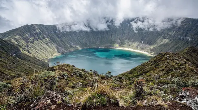
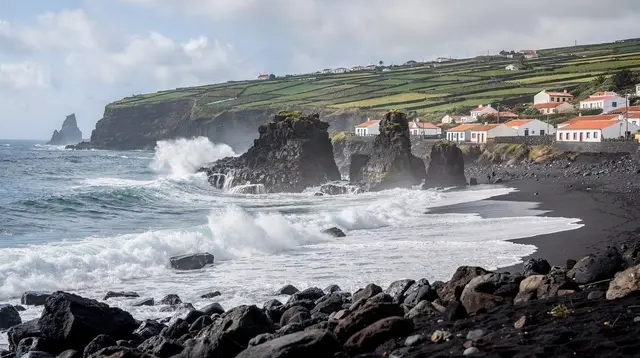
Povoação sits on São Miguel’s southeast coast, in the stretch of road between Furnas and Nordeste. Most travelers meet it as a waypoint rather than a destination: a small town at the foot of a steep valley, where the road drops from the hills to the Atlantic before climbing on toward Ribeira Quente and Faial da Terra. It is not a headline stop on most itineraries, and it does not need to be — its value is geographic, as the point where the Furnas caldera gives way to the folded, valley-cut coastline that runs on to the island’s eastern tip.
Where Povoação sits on the island
The east of São Miguel is shaped by a sequence of volcanic systems rather than one continuous ridge: the Furnas caldera inland, the laurel-forested highlands of the Serra da Tronqueira further east, and, threaded between them, a coastline cut by short, steep river valleys — locally ribeiras — that run straight down from the interior to the sea.
Povoação sits at the mouth of one of these valleys, where farmland terraces the slopes above the town and the land drops quickly to a rocky shore. This is the terrain that defines the whole stretch between Furnas and Nordeste: not a single caldera, but a landscape of ridges and valleys, more folded and more vertical than the gentler country around Ponta Delgada or the Sete Cidades caldera in the west.
The municipality of Povoação is one of the older settlements on São Miguel, and tradition places some of the island’s earliest Portuguese settlement here, in the first decades after the Azores were reached in the 15th century. Little of that early history is visible today in monument form — this is a working town, not a curated historic centre — but the setting itself, a sheltered valley mouth on an otherwise exposed coast, explains why early settlers chose it.
A coastal town, not a caldera village
It is worth being precise about what Povoação is, because it is easy to blur with its better-known neighbour. Furnas is a village built inside an active volcanic caldera, ringed by hills, with steaming ground, mineral springs and a lake at its centre. Povoação is a different kind of place entirely: a coastal town and municipality on the open Atlantic, at the bottom of a valley rather than inside a crater.
The two are close together on the map and connected by the same road, but they are not the same landscape, and a page or a plan that treats them as interchangeable will send visitors looking for the wrong thing in the wrong place. If it’s the caldera, the cozido pits and the thermal pools you’re after, that is Furnas itself, not Povoação — see the Furnas day trip guide for that side of things.
Povoação’s own centre is modest: a harbour used by local fishing boats, a parish church, a cluster of streets climbing the valley sides, and the agricultural terraces that are still worked above the town. There is no thermal park here and no equivalent of Furnas’ gardens — the town’s role on an itinerary is as a coastal waypoint and a base for the road on to Ribeira Quente and Faial da Terra, not as a sightseeing stop in its own right.
Getting there and the road east
By rental car, Povoação is roughly 45 to 55 minutes from Ponta Delgada, most commonly reached via the EN1-1A through Furnas before the road descends to the coast. From Furnas itself, the drop down to Povoação takes only 10 to 15 minutes. This part of the island has no dual-carriageway via rápida — that road stops well to the west, around Ribeira Grande and Lagoa — so the route east of Furnas is a narrower, winding coastal road, slower than the map distance suggests.
There is no train on São Miguel, and while buses run this route, they follow school and work timetables rather than a sightseeing schedule, which makes a car the practical way to see this stretch of coast at your own pace. Fuel stations thin out east of Furnas, so it’s worth filling up before continuing toward Povoação, Ribeira Quente and the Nordeste circuit.
The road through Povoação is also the natural link between two different day-trip plans: the Furnas day trip inland, and the Nordeste coastal day trip further east. Many visitors drive this whole stretch in one loop, stopping briefly in Povoação on the way rather than treating it as a separate outing. For a longer version of the same idea, the four-day full-island itinerary and the Nordeste trail-focused itinerary both route through here.
On to Ribeira Quente and Faial da Terra
From Povoação, the coast road continues a short distance to Ribeira Quente, the beach settlement that sits on the far side of the ridge from Furnas — the two are connected by road but separated by the caldera’s rim, which is part of why Furnas itself has no beach of its own. A little further on, a turn inland leads to Faial da Terra, the small hamlet that serves as the trailhead for the Salto do Prego waterfall walk. Neither of those two places is covered in detail here — they each have their own page — but Povoação is effectively the gateway to both: the point where the main road forks toward the coast at Ribeira Quente or the valley trailhead at Faial da Terra.
a guided hike to the Salto do Prego waterfall from Faial da Terra, with a picnic stop along the trail, is one of the more popular ways to use this end of the island, and it starts from the road that runs through Povoação. For the fuller picture of that walk and the hamlet it starts from, see the Salto do Prego waterfall hike guide and the Povoação and Ribeira Quente day trip guide.
Things to do around Povoação
Povoação’s own attractions are limited by design — it is a small working town — but its coastal position makes it a reasonable base for a few activities that draw on the surrounding sea and hills rather than the town itself.
Boat trips along the coast. In season, boats run out of this stretch of the east coast, combining coastline views with stops for swimming where the sea allows. a coastal boat tour from Povoação with stops for swimming and water activities covers this directly, and a broader option, a private full-day boat tour around São Miguel’s coastline, can be arranged to take in this side of the island as part of a longer route.
As with all boat trips here, sailings are weather-dependent and can be cancelled at short notice — there is no ferry service from mainland Portugal to the Azores at all, and inter-island and coastal boat trips are a separate, much smaller-scale affair; see the guide to São Miguel’s boat tours and weather cancellations for how that usually plays out.
Jeep and 4x4 routes toward Nordeste. The valley-and-ridge terrain east of Povoação suits 4x4 touring better than most of the island, and routes heading toward the Nordeste viewpoints and the Serra da Tronqueira often pass this way. a jeep excursion covering the Nordeste viewpoints and the Serra da Tronqueira mountains is one way to see this ground without driving it yourself on the narrower back roads.
Canyoning in the nearby ravines. The steep, water-cut valleys that define this part of the coast are also used for canyoning further into the Nordeste hills. a canyoning trip through the Ribeira dos Caldeirões ravine is the closest organised version of that, combining abseiling and pools in the kind of terraced valley Povoação itself sits at the foot of. For context on what that activity actually involves, see the canyoning season and rainfall guide and the fitness and skill level guide.
Walking and viewpoints further east. Povoação is also a natural staging point before the Nordeste viewpoints — Ponta do Sossego and Ponta da Madrugada — and the laurel forest trail where the endemic priolo survives, covered in the Serra da Tronqueira priolo trail guide. None of this is within Povoação itself, but the town is the last real settlement before that stretch of road narrows and climbs.
Povoação and Furnas at a glance
| Povoação | Furnas | |
|---|---|---|
| Setting | Coastal town at a valley mouth | Inland village inside its own caldera |
| Known for | Waypoint on the east-coast road, harbour, boat trips | Cozido cooked in the ground, thermal pools, Terra Nostra garden |
| Beach nearby | No beach in town; sand is at Ribeira Quente | None — Furnas has no coastline of its own |
| Typical visit | A stop of 1-2 hours en route east | A half-day or full-day destination |
| Reached from Ponta Delgada | ~45-55 min by car | ~50-60 min by car |
Practical notes for this stretch of coast
There are no thermal pools, gardens or ticketed attractions in Povoação itself, so there is little to book in advance for the town beyond a boat trip in season. Fuel up before continuing east, since stations are sparse between here and Nordeste. Shops in small towns along this coast tend to close early and on Sundays, and mobile coverage can be patchy in the deeper valleys. The road onward toward Ribeira Quente and Faial da Terra is narrow and winding, typical of this part of the island, and — as everywhere on São Miguel — the weather can differ noticeably between the coast at Povoação and the hills a few minutes inland, so a clear morning here is no guarantee of a clear afternoon at a Nordeste viewpoint or on the Faial da Terra trail.
For planning the wider east-coast loop that Povoação sits within, the east coast versus west coast comparison and the Furnas or Ponta Delgada as your base guide both help place Povoação within a full-island plan, and the guide to Ribeira Quente and Povoação as a day trip sets out a route combining this town with its neighbours in a single outing.
Povoação and the east coast: your questions answered
Is Povoação the same place as Furnas?
No. Furnas is an inland village inside its own active caldera, known for its steaming ground and thermal pools. Povoação is a separate coastal town and municipality a short drive away, at the mouth of a valley on the Atlantic. They sit next to each other on the map but are two distinct places with different landscapes.
How do I get to Povoação from Ponta Delgada?
By rental car, allow roughly 45 to 55 minutes. The route runs east along the EN1-1A, usually via Furnas, then drops down the valley road to the coast. There is no train on São Miguel, and buses run on limited timetables rather than tourist schedules, so a car is the practical way to reach this stretch of coast.
What is there to see in Povoação itself?
Povoação is a working coastal town rather than a sight in its own right: a small harbour, a parish church, terraced valley farmland, and views back up toward the surrounding hills. Most visitors pass through on the way between Furnas and Nordeste, or use it as the turn-off point for Ribeira Quente and Faial da Terra.
Can I combine Povoação with Ribeira Quente and Faial da Terra in one day?
Yes, this is the usual way to see all three. The coast road links Povoação to Ribeira Quente in a few minutes and on to Faial da Terra shortly after, so a single loop covering Furnas, Povoação, Ribeira Quente and Faial da Terra fits comfortably into one day with a rental car.
When is the best time to visit Povoação?
April to October gives the clearest roads and the best chance of a boat trip running along this stretch of coast. Like the rest of São Miguel, the weather here can change within the day, so treat any forecast as provisional rather than fixed.
Is there a boat tour from Povoação?
Yes, boat trips departing this stretch of the east coast run in season, combining the coastline views with stops for swimming or snorkelling where conditions allow. As with all boat trips on São Miguel, sailings depend on the sea state and can be cancelled or rescheduled at short notice.
Does Povoação have its own beach?
Povoação’s own coastline is rocky rather than a swimming beach. The nearest sand and the area’s boat-trip embarkation point most visitors head for is Ribeira Quente, a short drive further along the coast road, which has its own dedicated page.