São Miguel's Volcanic Story: From Furnas to Ferraria
What is São Miguel's volcanic history in brief?
São Miguel is built from a chain of overlapping volcanic systems, including Sete Cidades, Água de Pau and Furnas, still active enough to heat pools and cook food underground. Its highest point, Pico da Vara, reaches 1,103 m with no glacier and no ski infrastructure. In 1522 an earthquake-triggered landslide destroyed the original capital, Vila Franca do Campo, which is why the capital moved to Ponta Delgada.
São Miguel does not look like a typical Atlantic island because it is not one landform but several, stitched together over hundreds of thousands of years by overlapping volcanoes. Every postcard view on the island — a crater lake, a steaming village, a hot spring in the surf — is the same underlying story told at a different site. This guide is the map of that story: how the island was built, where its heat still surfaces today, and the one event, in 1522, that changed where its people chose to live. For the detail of any single site, from the fumaroles at Furnas to the crater lakes of Sete Cidades, the linked guides below go deeper than this overview does.
Why São Miguel Looks the Way It Does
São Miguel is not one volcano but a line of them, fused together along a roughly 65 km stretch of the mid-Atlantic ridge. Geologists usually describe three main active or recently active systems: Sete Cidades in the west, the Água de Pau massif in the centre (which includes Lagoa do Fogo and, further north, Caldeira Velha), and Furnas in the east. Smaller vents and cinder cones fill the gaps between them, which is why the drive along the EN1-1A constantly changes character — pasture and hedgerow give way, without warning, to a crater rim or a fumarole field.
The island’s shape is the direct result of that construction: long and narrow, dominated by broad shield-like slopes rather than a single sharp peak, with a coastline made largely of lava cliffs and black volcanic sand rather than coral or limestone. There is no single “São Miguel volcano” to point to — there is a chain, and every low-lying part of the island sits between two or more of its craters. Understanding that chain makes the rest of a first visit easier to place: Ponta Delgada grew on the flatter ground between systems, while the more dramatic sights cluster around the calderas themselves.
Furnas: A Caldera Still at Work
Furnas, in the east of the island, is the clearest place to feel that the volcano underneath São Miguel has not gone quiet. The village sits inside its own caldera, and the ground around the Lagoa das Furnas still steams: caldeiras vent sulphurous gas and boiling water at the surface, hot enough that restaurants use pits dug into the ground beside the lake to slow-cook cozido, the local stew, on volcanic heat alone rather than a fire. The pots go in mid-morning and come out at midday, cooked entirely by the earth.
This overview will not walk through Furnas’ fumarole field step by step — the Furnas caldera and fumaroles guide covers that in detail, along with the iron-rich pool at Terra Nostra Park and the smaller pools at Poça da Dona Beija. What matters here is the geology behind it: Furnas is an active caldera, not a dormant one, and every hot spring, steaming vent and underground kitchen in the area is powered by the same heat source a few hundred metres below the surface.
Caldeira Velha: Heat Piped Downhill
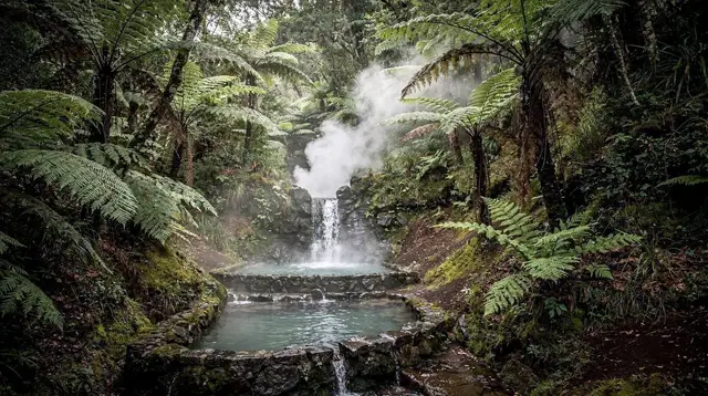
A short drive north of the central highlands, on the lower slope of the Água de Pau massif, Caldeira Velha shows a different expression of the same volcanic system that feeds Lagoa do Fogo higher up the mountain. Rainwater and groundwater are heated underground and emerge as a warm waterfall and a series of pools set among tree ferns, close enough to Ribeira Grande to visit in an hour without a long detour.
Caldeira Velha is often paired on itineraries with the tea plantations further along the north coast, but geologically it belongs with Furnas and Ferraria as one of the island’s readable heat sources — a place where the volcano’s warmth reaches the surface gently, through water, rather than violently. The short walk and swim there is covered in the Caldeira Velha thermal waterfall guide; this overview groups it alongside Furnas and Ferraria simply to show the pattern: three very different-feeling places, one shared cause.
Ponta da Ferraria: Lava Meets the Atlantic
At the island’s western tip, Ponta da Ferraria is where the volcanic story meets the ocean directly. A hot spring surfaces at the base of an old lava flow, right at the shoreline, warming a natural pool that only forms properly around low tide — at high tide or in any swell, the sea takes over and the spot is not usable, let alone safe. A paid spa sits above the tidal pools and is a separate facility with its own hours, distinct from the free sea-level pool the tide creates and removes twice a day.
Ferraria is a useful site for understanding the island’s geology because it makes the connection between lava and heat visible in one place: the black rock underfoot is a solidified flow, and the warmth rising through it is the same volcanic heat that surfaces as steam at Furnas and as a waterfall at Caldeira Velha. Tide times and safety are covered fully in the Ponta da Ferraria tide times guide.
Vila Franca do Campo: The Day the Ground Gave Way
Not every mark the island’s volcanic past has left is a pool or a viewpoint. On the south coast, Vila Franca do Campo was the capital of São Miguel until 1522, when an earthquake — a routine hazard on ground this volcanically active — triggered a landslide that buried much of the town. It was one of the deadliest disasters in Azorean history, and it permanently changed the island’s balance of power: administration shifted west to Ponta Delgada, which has remained the capital in the five centuries since.
Vila Franca rebuilt on the same coast, and today gives no visible sign of the disaster beyond the chapel of Nossa Senhora da Paz on the hill above town, built afterward as an act of thanks for the town’s survival. Just offshore, the Ilhéu de Vila Franca — a nearly perfect circular islet — is itself a drowned crater, swimmable inside in season and capped daily to protect it. The 1522 landslide is the clearest reminder on the island that its volcanic ground is not only a source of scenery and warm water: it has, once, decided where the capital of São Miguel would be. The full account is in the Vila Franca do Campo former capital guide.
Pico da Vara: The Island’s High Point, Not a Peak to Climb in Crampons
In the far east of the island, beyond Furnas and Nordeste, Pico da Vara reaches 1,103 m — the highest point on São Miguel and in the entire Azores archipelago. It is worth stating plainly what it is not: there are no Alps here, no glacier, no permanent snow, and no ski resort or cable car anywhere on the mountain or the island. Pico da Vara is a volcanic summit reached on foot, through the laurel forest of the Serra da Tronqueira that shelters the priolo, one of Europe’s rarest birds, found nowhere else on Earth.
The summit sits well back from the coast roads and gets little passing traffic — reaching it is a dedicated hike, not a stop on a driving loop, and cloud cover often hides the top even on a clear day at sea level. It closes this overview’s list of sites for a reason: after the steaming caldeiras of Furnas, the piped heat of Caldeira Velha and the tidal spring at Ferraria, Pico da Vara is the quietest kind of volcanic landmark on the island — simply the accumulated height of everything built beneath it. Trail specifics are covered in the Pico da Vara summits guide.
Reading the Rest of the Island’s Volcanic Record
Furnas, Caldeira Velha, Ferraria, Vila Franca and Pico da Vara are not the whole picture — they are the sites this particular overview set out to connect. Two other landmarks belong in the same volcanic story but get their own dedicated guides rather than detailed treatment here. Sete Cidades, the twin-lake caldera in the west, is explained fully in the Sete Cidades volcano guide, and Lagoa do Fogo, the bare crater lake at the island’s centre, has its own crater lake guide.
Closer to Ponta Delgada, the Gruta do Carvão lava tube shows the same story underground: a channel a flow of lava once ran through, now hollow and walkable at the edge of the capital. For a plain-language explanation of how a caldera differs from a crater lake and a lava tube, the calderas versus lava tubes guide is the reference to read next; this overview deliberately stays at the level of “which system feeds which site” rather than repeating that detail.
Living on an Active Island: Practicalities
None of this makes São Miguel a dangerous place to visit — hundreds of thousands of people walk its crater rims and thermal pools every year without incident — but it is worth traveling with a volcanic island’s habits rather than a purely scenic one’s. Roads to the higher craters, including the passes to Lagoa do Fogo and Sete Cidades, are sometimes closed by fog or maintenance; check conditions the morning of, not the night before. Thermal water stains and can be sharply hot at the source, so treat marked temperatures and lifeguard or staff guidance at each pool as real instructions, not suggestions.
Trail closures after landslides are common enough on this ground that the regional trails network publishes current PR-numbered path status; it is worth a check before any hike into the highlands or the Nordeste coast. None of this requires special equipment beyond sturdy shoes and a rain layer — the what to pack guide covers what actually gets used on a volcanic-sites day, and it is closer to a hiking daypack than expedition gear.
Seeing It For Yourself
Most visitors piece this geology together across several separate days rather than one, and a guided option often makes the highland roads easier than a first-time self-drive. A full loop such as the full-day jeep tour around São Miguel strings together several of these systems — coastal lava, central crater, eastern caldera — in a single outing with a driver who knows which passes are open that day. Travelers focused on the western caldera specifically often prefer the quad buggy ride around the Sete Cidades crater rim, which gets close to the twin lakes without a long walk.
For the eastern side of the island, a guided Furnas day combining the volcanic valley with a tea plantation and lunch pairs the geology with two of the island’s other signature stops in one trip.
Anyone drawn more to the crater lake at the island’s centre than its steaming villages can instead book the full-day guided hike up to Lagoa do Fogo, which reaches the rim on foot rather than by road. None of these replace a look at the individual destination and activity guides linked throughout this page — they are simply the easiest way to reach ground that a rental car alone sometimes cannot, especially when a pass is fogbound.
FAQ: São Miguel’s Volcanic History and Sites
Is São Miguel still volcanically active?
Yes. There is no lava eruption to see today, but the island’s heat is live and visible at Furnas’ steaming caldeiras, the hot spring at Ponta da Ferraria, and the thermal waterfall at Caldeira Velha. Small earthquakes are routine on the island and are rarely felt by visitors.
What is the highest point on São Miguel, and can you ski there?
Pico da Vara, at 1,103 m in the eastern highlands, is the island’s summit. There is no glacier, no ski lift and no cable car anywhere on São Miguel — the peak is reached on foot through laurel forest, not by any winter-sports infrastructure.
Why did the Azorean capital move from Vila Franca do Campo to Ponta Delgada?
In 1522 an earthquake set off a landslide that buried Vila Franca do Campo, then the island’s capital. The survivors rebuilt, but administrative power shifted west to Ponta Delgada, which has remained the capital ever since.
Are Furnas and Caldeira Velha part of the same volcano?
No. Furnas is its own caldera in the east of the island, while Caldeira Velha sits on the slope of the separate Água de Pau volcanic massif above Ribeira Grande. São Miguel is a chain of distinct volcanic centres, not one single cone.
Is it safe to visit São Miguel’s volcanic sites?
Yes, with ordinary care. Marked paths, viewpoints and pools are maintained and widely visited every year; the real risks are unfenced cliff edges, sudden fog on the crater roads, and hot water at the thermal sites rather than eruption risk.
Can you see lava flows or a crater rim up close on São Miguel?
You can walk crater rims and lava-built coastline, but there is no open lava to view — the island’s last confirmed eruptions were centuries ago. What you see instead is the shape lava and collapse left behind: calderas, cinder cones and a lava tube at Gruta do Carvão.
Volcanoes & Craters on GetYourGuide
Verified deep-linked GetYourGuide tours. Book through these links and we earn a small commission at no cost to you.
GetYourGuide does not provide a product photo for this activity — the image shows the meeting point, photographed by us.