A Town, Not a Lake
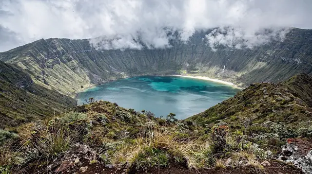
Say “Lagoa” on São Miguel and most visitors picture water — the twin lakes at Sete Cidades, the crater lake of Lagoa do Fogo, or the cooking pits of Lagoa das Furnas. None of those is this page. Lagoa here is a municipality and town on the south coast, sitting on the coast road between Ponta Delgada and Vila Franca do Campo.
It has no lake of its own. The name is simply the Portuguese word for a body of still water, and the island reuses it four times over for four unrelated places — three volcanic lakes and one town. Locals rarely confuse them because context makes it obvious; visitors reading an itinerary or a map for the first time often do.
That confusion is worth clearing up before anything else, because it changes what you should expect to find here. This is not a crater, not a viewpoint over a lake, and not a nature reserve. It is an ordinary, working stretch of São Miguel’s coast: parish churches, vineyards on volcanic soil, a scatter of villages, and a municipal boundary that happens to share its name with the island’s most photographed lakes.
Where Lagoa Sits on the Map
The municipality of Lagoa runs along the south coast for a short stretch between the outskirts of Ponta Delgada and the boundary with Vila Franca do Campo. It is one of the smaller of São Miguel’s six municipalities by area, but it sits on the island’s busiest road corridor — the same route that carries traffic from the airport and capital toward Furnas and the east. Anyone driving the south coast passes through it, usually without stopping.
Two villages inside the municipality do the heavy lifting for visitors: Água de Pau, on the coast road itself, and Caloura, a small harbour tucked into a cove below. Both are covered on their own pages and are not repeated here in detail — this page exists as the geographic anchor that ties them together, not as a duplicate of either. If you are looking for swimming spots, a harbour with boats, or a coastal path, those two pages are the better starting point; this one is for understanding how the pieces of the south coast fit.
What’s Actually in Lagoa
The town centre of Lagoa is workaday rather than picturesque: a parish church, a scatter of shops and cafés, and the packing houses and cellars tied to the area’s small wine tradition. São Miguel’s volcanic soil and Atlantic exposure support a modest wine industry on lava-field vineyards near the coast, distinct from the UNESCO-listed vineyards on the island of Pico — a useful distinction, since the two are sometimes mixed up in guidebooks. A guided visit to a local apiary is one of the few bookable activities based in this stretch of coast, and it is a low-key way to spend an hour if you are already in the area rather than a reason to detour on its own.
a guided apiary visit near Lagoa pairs well with a slow morning on the south coast, walking through hives and tasting local honey rather than covering distance.
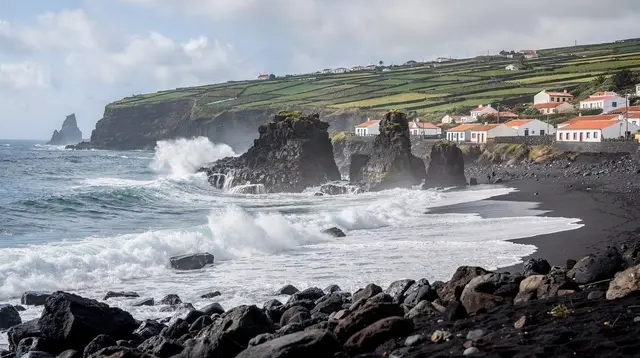
Beyond the town, the municipality’s coastline is where most visitors actually spend their time, and that coastline belongs to Caloura and to the stretch around Água de Pau, both detailed on their own pages. What Lagoa contributes as a place-name is less a single sight than a frame: it is the municipal identity that holds together a run of coast between two better-known anchors, Ponta Delgada and Vila Franca do Campo.
Água de Pau and the Municipality’s Reach
Água de Pau sits directly on the EN1-1A coast road within the Lagoa municipality, close enough to the town centre that the two often blur into one stretch of settlement when you drive through. It has its own destination page with its own detail on swimming spots and village life; here it is enough to know that when a route description says “through Lagoa,” it usually means this section of coast road, Água de Pau included. The massif above Água de Pau climbs toward the interior and eventually toward Lagoa do Fogo — the crater lake, not the town — which is one of the two access routes up to that reserve.
a half-day tour up to Lagoa do Fogo is a natural add-on if you are already on this stretch of coast and want the crater-lake viewpoint rather than the town of Lagoa itself — worth confirming which one you’re booking, given the shared name.
Caloura, the Harbour Next Door
Caloura is the municipality’s other well-known anchor, a small fishing harbour with a slipway, a couple of restaurants and one of the south coast’s more sheltered spots to get into the water. It has its own full page with swimming and boat-trip detail, so it isn’t repeated at length here. What matters for orientation is that Caloura sits a short drive from Lagoa’s town centre, on the seaward side of the same municipality, and that day plans covering “the Lagoa area” usually mean some combination of the town, Água de Pau and Caloura strung along a few kilometres of coast.
Lagoa as a South-Coast Waypoint
Most visitors experience Lagoa as something they drive through rather than somewhere they stop for a full day, and that is a reasonable way to treat it. The municipality’s real appeal is as a connective stretch of coast between two more compelling anchors — the capital and Vila Franca do Campo — with Caloura and Água de Pau as the worthwhile pauses along the way. Treat the town centre itself as an occasional errand stop or a quiet coffee break rather than a headline destination, and the geography starts to make sense.
For travellers renting a car, this is one of the easier stretches of the EN1-1A to drive: wide, well-surfaced road, light traffic outside the Ponta Delgada commute hours, and clear signage toward each village. It’s a good example of how the island’s road network works — main routes hug the coast and thread through municipality after municipality, each with its own name and character, before delivering you to the next headline stop.
Getting To and Through Lagoa
There is no dedicated visitor infrastructure here — no ticket office, no tourist information point specific to the town — so getting to Lagoa is simply a matter of driving the coast road. From Ponta Delgada it’s a short run east on the EN1-1A, past the airport turn-off and out along the coast; from Vila Franca do Campo it’s an equally short run west. Public buses connect the corridor, but as with the rest of the island they run on commuter timetables rather than sightseeing ones, so a rental car remains the practical way to link Lagoa with Caloura, Água de Pau and the villages further along.
There’s no reason to base yourself overnight in Lagoa specifically. Most visitors stay in Ponta Delgada, Vila Franca do Campo or further east near Furnas, and treat this stretch of coast as a stop along a longer drive rather than a base of its own. If your plan for the south coast is built around a multi-day route, see the island’s three-day itinerary for how a corridor like this typically slots between the capital and the caldera towns further east.
Vila Franca do Campo, Just Along the Coast
Vila Franca do Campo, a few kilometres further along the same road, was São Miguel’s original capital until a 1522 landslide buried it, and it remains the more substantial stop on this stretch of coast — a proper town with a marina, restaurants, and the boat departures for the crater islet just offshore. Many visitors treat Lagoa and Caloura as a scenic detour on the way to or from Vila Franca do Campo rather than as a separate destination, and that’s a sensible way to sequence a day.
a half-day tour covering Vila Franca do Campo and this stretch of the south coast is the most efficient way to see both the town and the coastline around Lagoa without renting a car for a single afternoon.
If you have a full day rather than half, the crater islet trip out of Vila Franca do Campo’s marina is worth building around; see the dedicated guide on boat trips to the Ilhéu de Vila Franca for the visitor-cap and seasonal detail, and the guide to kayaking the south coast between Vila Franca do Campo and Caloura if you’d rather see this stretch of water from a boat than a car window. Snorkellers based around Caloura’s sheltered cove should read the dedicated Caloura snorkelling guide before getting in the water.
When to Visit
There’s no season that makes or breaks a visit to Lagoa the way there is for, say, whale watching or hydrangea season elsewhere on the island — this is a drive-through stretch of coast, and the coast road stays open and usable year-round.
That said, the practical sweet spot mirrors the rest of the south coast: June to September brings the driest, warmest days for stopping at Caloura’s waterfront or walking around Água de Pau, while the shoulder months of April to June and September to October offer quieter roads and lower prices with only a modest trade-off in weather reliability. November to March is mild but wet and windy, which matters less here than at an exposed viewpoint, since most of what there is to see in Lagoa itself is at ground level rather than dependent on a clear sky.
Whatever the season, remember that São Migul’s weather is hyper-local: it can be raining at Lagoa do Fogo above while the coast road through Lagoa stays dry, so don’t let inland cloud cover change your south-coast plans.
Tours and Activities from the South Coast
Because Lagoa itself has limited standalone activity, most bookable tours that touch this area are based either in Vila Franca do Campo or up at Lagoa do Fogo, both reachable from here in under half an hour.
| Activity | Starts from | Typical length |
|---|---|---|
| Apiary and honey tasting | Near Lagoa | 1-2 hours |
| Vila Franca do Campo half-day tour | Ponta Delgada or Vila Franca do Campo | Half day |
| Lagoa do Fogo half-day tour | South coast or Ribeira Grande side | Half day |
| Lagoa do Fogo full-day hike | Trailhead access points | Full day |
| Whale watching with lunch | Ponta Delgada marina | Half to full day |
a whale watching trip with lunch and water activities departs from Ponta Delgada’s marina rather than from Lagoa itself, but it’s a realistic pairing for a south-coast day if you’re staying nearby and want to add the ocean to a morning spent on land.
For hikers rather than drivers, the Lagoa do Fogo hiking trail guide covers the crater-lake route in detail — again, a different Lagoa from the town covered on this page, and worth double-checking before you book.
Lagoa on São Miguel: Clearing Up the Name
The recurring question about this part of the island isn’t really about sights — it’s about which “Lagoa” a given recommendation, tour listing or map pin actually means. The questions below cover the confusion directly.
Is Lagoa a lake or a town on São Miguel?
Lagoa is a municipality and town on São Miguel’s south coast, between Ponta Delgada and Vila Franca do Campo. It is not a body of water. The island’s actual crater lakes with similar-sounding names are Lagoa Azul and Lagoa Verde at Sete Cidades, Lagoa do Fogo in the island’s centre, and Lagoa das Furnas in the eastern caldera.
How do I get from Ponta Delgada to Lagoa?
Lagoa is about 12 km from Ponta Delgada, roughly 15 minutes by car along the EN1-1A coast road heading east. There is no dedicated bus service aimed at visitors; local buses run on commuter timetables rather than sightseeing schedules, so a rental car is the practical option.
Is Lagoa the same place as Lagoa do Fogo?
No. Lagoa do Fogo is a crater lake in the middle of São Miguel, a nature reserve with no facilities and frequent cloud cover. Lagoa, the subject of this page, is a coastal town and municipality on the south coast, roughly 15-20 minutes’ drive from the Lagoa do Fogo access roads. They share a name but nothing else.
What is there to do in Lagoa itself?
The town centre is modest: a parish church, local shops, small wineries working the coastal lava-field vineyards, and an apiary that runs guided tastings. Most of what visitors come to the municipality for — swimming, a harbour, coastal walks — is in Caloura and Água de Pau, both a short drive away and covered on their own pages.
Should I stay overnight in Lagoa?
Most visitors don’t. Ponta Delgada, Vila Franca do Campo and the Furnas area are the more common bases on this side of the island, with Lagoa, Água de Pau and Caloura treated as stops along the coast road rather than overnight destinations.
How does Lagoa relate to Caloura and Água de Pau?
Both are villages within the Lagoa municipality. Água de Pau sits directly on the coast road close to the town centre; Caloura is a small harbour a short drive off the main road. Each has its own dedicated page with swimming, dining and activity detail — this page is the geographic anchor connecting the three.
Can I combine Lagoa with Vila Franca do Campo in one day?
Yes, easily. The two are about 6 km apart, roughly a 10-minute drive, and are typically covered together as a single south-coast outing that also takes in Caloura or Água de Pau along the way, before or after the more substantial stop at Vila Franca do Campo itself.
Why does São Miguel use “Lagoa” for so many different places?
Lagoa simply means “lagoon” or “lake” in Portuguese, and the island applies it descriptively wherever there’s a notable body of still water — at Sete Cidades, in the Lagoa do Fogo crater, and at Furnas — as well as to this south-coast municipality, whose name predates and is unrelated to any of the volcanic lakes. It’s a naming coincidence rather than a shared identity.