Lagoa do Fogo Has No Café, No Toilets, No Guaranteed View
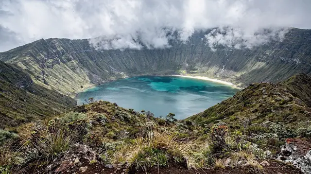
The first time I drove up to Lagoa do Fogo I had a picture in my head that came straight off a postcard rack in Ponta Delgada: a sharp blue lake ringed by green crater walls, a wooden platform to stand on, maybe a stall selling coffee. I got a car park, a stone wall, and white. Not mist drifting past — white, all the way round, thick enough that I couldn’t see the bonnet of my own rental car from ten paces. I stood there for twenty minutes waiting for it to lift. It didn’t.
That was my mistake, not the mountain’s. I had quietly assumed Lagoa do Fogo would work like Sete Cidades, the other famous crater lake on the island — a village down in the caldera, cafés, a viewpoint with railings and a car park attendant. Lagoa do Fogo is nothing like that, and once you know why, it stops being a disappointment and starts being one of the more honest places on São Miguel.
Why there is nothing built up here
Lagoa do Fogo sits inside a protected nature reserve in the middle of the island, at real altitude, on ground too exposed and too ecologically sensitive to develop. There is no café at the upper viewpoint. There is no ticket office, because nobody is selling you a view. There are no bins, so whatever you carry up you carry back down. And there are no toilets, at the viewpoint or down by the lake shore — the nearest ones are back down the slope in Água de Pau or Ribeira Grande. If you have driven the Sete Cidades loop that morning and expect the same kind of stop, recalibrate before you leave Ponta Delgada.
This isn’t neglect. It’s the same instinct that keeps priolo habitat fenced off in the east of the island: some places on São Miguel are left alone on purpose. I’ve come to like that Lagoa do Fogo doesn’t perform for visitors. It just sits there, being a volcano, whether or not anyone shows up to look at it.
The view is not a guarantee, it’s a chance
The second thing nobody told me clearly enough: cloud forms around this crater on a large share of days, in every season, because of the altitude and the way moist Atlantic air gets pushed up and over the rim. I’ve now been up three times. Once, total white-out. Once, a lake that appeared for maybe ninety seconds through a gap and then vanished again. Once, genuinely brilliant, the water a flat green-blue with the whole bowl of the crater visible end to end. Same road, same car park, three completely different outcomes.
If you only take one thing from this piece, take this: do not build a whole day’s itinerary around a guaranteed photo at Lagoa do Fogo. Build a day where the crater is a bonus if it clears, and something else entirely if it doesn’t. The island’s own weather changes hour by hour and pocket by pocket — it can be raining in Furnas while Ponta Delgada is dry, and clear at the coast while the crater rim is buried. Check a live webcam or a local forecast before you commit to the drive, not the general weekly forecast for “the Azores.”
The road up is not always open
The access road climbs fast into thin, windy, sometimes fog-bound terrain, and the authorities do close it — not as a bureaucratic formality but because driving blind along an unguarded mountain road in near-zero visibility is genuinely dangerous. I’ve turned around once myself, waved back down by a barrier I hadn’t seen mentioned anywhere online that morning. Ask locally, check a Sete Cidades or Lagoa do Fogo status page, or just look at the sky from Ribeira Grande before you start climbing.
For anyone who wants the crater without gambling a full morning on it, going with someone who already checks conditions before setting out removes most of the risk. A half-day jeep trip up to the crater will simply not leave if the lake is socked in, which is worth more than it sounds. The same goes for a combined day covering both Sete Cidades and Lagoa do Fogo, where a driver who knows the access road can shift the order of stops around the weather rather than around a fixed script.
Walking it instead of just driving up
My best visit wasn’t the drive-up-and-look kind at all. I parked below the crater and walked in on the hiking trail that drops down to the shoreline, which takes a couple of hours round trip and does something the viewpoint car park can’t: it puts you inside the crater rather than looking down into it. Cattle graze right up near the rim in places, which is a small, useful reminder that this is a working, farmed island as much as it is wilderness — pasture and volcano share the same slope here.
If a full hike isn’t for you, the short version — a walk of twenty or thirty minutes from the main viewpoint along the rim path — still gets you further than most day-trippers bother to go, and the crater looks different from even fifty metres along the ridge. There’s a companion guide to what to expect when the clouds actually clear if you want to know what you’re hoping for.
What I’d tell you before you go
Treat Lagoa do Fogo as a nature reserve you’re lucky to see clearly, not a monument you’re owed a look at. Pack water, food, a waterproof layer and decent shoes, because there is nothing to buy once you’re up there. Check the weather and the road status that same morning rather than the night before — conditions here shift by the hour. Read a proper day-trip guide or a route-by-route crater guide so you know your options if you arrive to white-out.
And if you’d rather not do the guessing yourself, a guided hike down into the crater with someone checking conditions on the day takes that decision off your hands. It’s still not a promise — nobody can promise you Lagoa do Fogo. But going in expecting a raw, unbuilt, occasionally invisible volcano, rather than a viewpoint with a gift shop, is what actually gets you the good version of this place.
Plan the rest of your route with a wider look at when to visit São Miguel, or sort out a rental car and what driving here is actually like before you commit to the climb — a car you trust on narrow mountain roads matters more here than almost anywhere else on the island. Check the sky, check the road, and go up expecting nothing except a volcano.
Questions I get asked about Lagoa do Fogo
Does Lagoa do Fogo have a café or restaurant?
No. There is nothing to buy at either the upper viewpoint or the lake shore. Bring your own water and food, and carry your rubbish back down with you.
Are there toilets at Lagoa do Fogo?
There are none at the viewpoint and none by the lake. The nearest toilets are back down the mountain in Água de Pau or Ribeira Grande, so plan ahead, especially with children.
Is the view of Lagoa do Fogo guaranteed?
No. The crater sits high enough that cloud forms around it on a large share of days, in any season. Locals check the sky before driving up rather than trusting a fixed schedule.
Can the road to Lagoa do Fogo be closed?
Yes. The access road climbs into thin, exposed terrain and is sometimes closed by the authorities in dense fog or strong wind, for safety rather than as a formality. Always have a fallback plan for the day.
Is Lagoa do Fogo the same kind of stop as Sete Cidades?
No. Sete Cidades has a village, cafés and viewpoints with parking and railings. Lagoa do Fogo is an undeveloped nature reserve with none of that, even though both are crater lakes on the same island.
Can you swim in Lagoa do Fogo?
Swimming is discouraged and, in parts, restricted, since the lake sits inside a protected reserve. Most visitors come for the walk and the view, not for a swim.
What should I bring to Lagoa do Fogo?
Water, food, a waterproof layer, sturdy shoes and a phone with the weather checked beforehand. There is nothing to buy once you are up there, and the weather can turn quickly.
Is a guided tour worth it for Lagoa do Fogo?
A guide or driver who checks conditions that morning and knows the road well can save a wasted trip, since they will not drive up into a cloud that a webcam or forecast already shows.
tours.Mistakes
Verified deep-linked GetYourGuide tours. Book through these links and we earn a small commission at no cost to you.
GetYourGuide does not provide a product photo for this activity — the image shows the meeting point, photographed by us.