Best Cycling Routes on São Miguel
What are the best cycling routes on São Miguel?
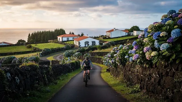
The rolling coastal stretch linking Ribeira Grande, Praia de Santa Bárbara and the Gorreana tea plantations is the island's most reliable riding, on gentler gradients than the interior. The climb to Lagoa do Fogo on the EN5-2A is steep, often fogbound or windswept, and should not be planned as a guaranteed cycling route at any time of year.
Reading the island by terrain, not by map distance
São Miguel looks compact on a map — 65 km end to end, never more than about 15 km across — but distance tells you almost nothing about how a route will actually ride. The island was built by volcanoes, and it still behaves like one: gentle, rolling ground along stretches of the coast, and abrupt climbs into caldera rims and central massifs everywhere else. Two rides of the same length can differ enormously in effort, weather exposure and reliability.
This guide sorts the island’s cycling ground by area, so the choice of route follows the terrain rather than a straight line on a map. It does not cover bike or e-bike rental logistics, which are handled in our e-bike rental guide, and it does not repeat the general groundwork on cycling here, laid out in our overview of cycling on São Miguel — this page is about which stretches of road are worth your legs, and which ones are not a fair bet.
The north coast: the island’s most rideable stretch
If one part of São Miguel rewards a bike more consistently than any other, it is the coastal run along the north shore. Starting from Ribeira Grande, the island’s second town, the road follows the shoreline west and east with far gentler gradients than the interior offers.
It passes close to Praia de Santa Bárbara, the island’s main surf beach, where a flat run along the dunes gives the legs a rest between the shorter climbs on either side. Continuing east, the road threads through pasture and hedgerow toward the Gorreana tea plantations, Europe’s oldest working tea estate, founded in 1883, where the fields themselves are laced with quiet farm tracks worth a slow loop before heading back.
What makes this stretch different from the rest of the island is not that it is flat — nothing on São Miguel really is — but that its climbs are short, its views open rather than closed in by cloud, and its villages close enough together that a mechanical problem or a sudden shower is rarely far from shelter. It is the closest thing on the island to a route you can commit to without a weather-dependent plan B.
| Segment | Terrain | Approx. distance | Notes |
|---|---|---|---|
| Ribeira Grande to Praia de Santa Bárbara | Coastal, rolling | 3-4 km | Short, exposed climb out of town |
| Praia de Santa Bárbara to Gorreana | Coastal, gentle rises | 8-10 km | Farm roads, light traffic |
| Gorreana loop through the tea fields | Flat to gently rolling | 3-5 km | Unpaved sections, slow riding |
| Full Ribeira Grande - Gorreana return | Coastal, rolling | 22-26 km | A full but manageable half-day |
Riders who want the north coast covered without route-planning it themselves can join a guided Ponta Delgada e-bike tour that handles the pacing and the stops, which is a reasonable way to see this stretch without spending the first hour working out where the road actually goes.
Why Lagoa do Fogo is not a cycling route
It needs saying plainly, because the map makes the road to Lagoa do Fogo look like an obvious loop: it is not a dependable cycling route, at any time of year. The access road, the EN5-2A, climbs steeply into the island’s central massif to reach the crater lake, and that altitude is exactly why it fails as a planned ride.
Fog forms and thickens on the pass with little warning, wind funnels hard along the exposed upper stretch, and the road itself is sometimes closed outright by the regional authorities when conditions turn. Lagoa do Fogo has no café, no shelter and no facilities of any kind at the top — a fact that matters far more to a cyclist caught in cloud than to a driver who can simply turn the car around and leave.
None of that makes the crater lake unworthwhile — it is one of the most striking sights on the island on a clear day, described in more detail in our Lagoa do Fogo crater lake guide and our notes on when the clouds actually clear.
It simply means the sensible way to see it is not to build a cycling day around the summit push. Riders who still want the interior in their legs are better served treating Lagoa do Fogo as a viewpoint reached by other means — an island-wide jeep tour can take in the crater on a day when the pass is actually open, without a bike ride’s worth of weather risk riding on it.
Furnas and the eastern interior: gravel country
The east of the island rewards a different kind of ride altogether. Furnas sits inside its own active caldera, ringed by steaming ground and dense forest, and the tracks around it mix sealed lanes with rougher farm and forestry gravel — terrain that suits a gravel bike far better than a road setup.
Loops around the Furnas basin take in the fumarole fields, the edge of the lake where cozido is cooked underground, and stretches of quiet farmland that never appear on a driving itinerary. Heading further east toward Nordeste, the ground gets harder still — steeper climbs between viewpoints, more exposed ridgelines, and longer gaps between villages — better suited to a full day out than a casual loop.
Because the connecting roads between Ponta Delgada and Furnas climb hard through the interior with little shelter, most riders who want this ground covered do better joining a guided ride that starts in Furnas itself rather than riding out to it cold. An e-gravel bike tour around Furnas covers the caldera’s mixed terrain with assisted climbing, which matters on ground this steep.
For riders who want the fullest cross-section of the island’s terrain in one outing, a guided coast-to-coast gravel route links the different textures of the island — coastal, interior and caldera — into a single supported day, which is a far steadier way to take on the harder ground than piecing it together solo.
The south coast and the interior ridges
South of Furnas, the ground drops back toward the sea at Vila Franca do Campo, the island’s old capital before a landslide buried it in 1522. The coastal road here rolls rather than climbs, similar in character to the north shore, though shorter and with less continuous distance to work with.
Further along the coast, the small harbour village of Caloura and the neighbouring stretch through Água de Pau continue the same rolling character, a shorter add-on for riders who have already covered Vila Franca do Campo and want a few more coastal kilometres before turning back. Inland from it, the ridge roads connecting the south coast to the central highlands climb quickly and are exposed to the same fog and wind that make the Lagoa do Fogo pass unreliable — a pattern worth remembering anywhere the road gains real altitude on this island, not just at the crater lake itself.
The practical read for a multi-day cycling trip is to treat São Miguel as two different kinds of riding stitched together: coastal stretches — north and south — that behave predictably enough to plan around, and interior or altitude routes that need a clear-weather day and a flexible plan rather than a fixed itinerary.
The west: Sete Cidades and the caldera rim
West of Ponta Delgada, the round trip out to Sete Cidades is short in kilometres but not one to underestimate on a bike. The village sits inside a caldera holding the twin lakes Lagoa Azul and Lagoa Verde, and every road in or out of that bowl drops or climbs the crater wall in one determined pitch — there is no way to visit Sete Cidades by bike that avoids a serious climb back up, whichever side of the rim you use.
Riders who take it on are rewarded with a descent that a car window softens far more than a saddle does: the twin lakes open up below well before the village itself comes into view, and the rim itself is covered step by step in our Sete Cidades caldera rim walk, useful background even for those riding rather than walking it, alongside the broader explanation of how the Sete Cidades volcano formed . A loop out toward Mosteiros on the coast beyond the caldera adds distance without adding much more climbing, since it hugs the shoreline past the black-sand beach and sea stacks rather than pushing back over the rim a second time.
As with Lagoa do Fogo, treat the caldera climb as weather-dependent rather than guaranteed: the rim catches the same cloud and wind that affects the island’s other high ground, and a clear descent into Sete Cidades in the morning is no guarantee of a clear climb back out in the afternoon.
What actually changes route to route
- Weather is local, not island-wide. It is entirely possible for the north coast to be dry and calm while the interior above Lagoa do Fogo sits inside cloud. Check conditions for the specific stretch you are riding, not a general island forecast.
- Gravel beats road tyres for anything inland. The coastal routes around Ribeira Grande and Gorreana are rideable on a road bike; almost everything around Furnas and the interior crossings is not. This overlaps with, but does not replace, the general cycling groundwork covered in our cycling on São Miguel overview.
- Villages are your shelter, not services. Outside Ponta Delgada and Ribeira Grande, bike shops and rental points thin out fast, so mechanical problems are best avoided rather than fixed on the road — check gears and brakes before setting out from town.
- Cattle and narrow lanes are the real hazard, more than traffic volume. Roads through farmland around Gorreana and the eastern interior are frequently shared with livestock being moved between fields.
Planning the ride around the rest of the island
A day built around the north coast pairs naturally with a stop at the Gorreana tea plantation guide for anyone curious about the fields the road runs through, or with a look at Praia de Santa Bárbara’s surf scene for a break at the halfway point.
For the interior and Furnas, it is worth reading how quickly conditions can flip between one side of the island and the other — our note on how weather changes hour to hour on São Miguel explains why a clear morning on the coast is no guarantee of a clear afternoon on a climb. And if the plan includes Sete Cidades or a wider loop of Nordeste on two wheels, treat both the same way as Lagoa do Fogo: worth checking on the day, never worth locking into a fixed schedule.
Where you base yourself changes how much of this is practical without a car shuttle. Staying in Ponta Delgada puts the north coast route and the Sete Cidades loop within a single day’s ride each, though Furnas and the far east are more realistically tackled as guided days than round trips from the capital. Our broader notes on where to stay on São Miguel and on reading the island month by month both help frame a cycling trip’s logistics beyond the roads themselves — when the rain is least likely, and which town puts you closest to the ground you actually want to ride.
Cycling routes on São Miguel: your questions answered
Is the road up to Lagoa do Fogo a good cycling route?
Not a dependable one. The EN5-2A is a narrow, steep climb into the island’s central massif, and it is regularly closed or made unrideable by fog and wind at altitude, in any season. Treat it as a possibility on a clear, calm day, never as a route you can plan a ride around.
What is the best area on São Miguel for road cycling?
The north coast between Ribeira Grande and the Gorreana tea plantations, taking in Praia de Santa Bárbara. The terrain there follows the coastline on gentler gradients than the volcanic interior, with more villages, cafés and traffic-light sections to break up the ride.
Can I cycle from Ponta Delgada to Furnas?
It is possible but demanding: the direct interior roads climb hard and offer little shelter from wind or rain. Most riders who want to see Furnas by bike do it from the Furnas side, on shorter loops around the caldera, or join a guided gravel ride that handles the harder connecting stretches.
Do I need a road bike, a gravel bike or a mountain bike here?
A gravel or hybrid bike suits São Miguel better than a pure road bike. Many worthwhile stretches, especially around Furnas and the coast-to-coast interior crossings, mix sealed road with rougher farm tracks, and the island’s frequent showers make wider, more forgiving tyres a real advantage.
Is cycling on São Miguel’s roads safe?
Roads are narrow almost everywhere, shoulders are rare, and cattle are sometimes walked along them between fields. Away from the Ponta Delgada to Ribeira Grande via rápida, traffic is generally light, but visibility drops fast in fog and rain, so lights and bright clothing matter more here than the low traffic volume suggests.
When is the best time of year to cycle São Miguel?
Late spring through early autumn gives the driest roads and the longest calm-weather windows, though showers can still arrive without warning in any month. Winter riding is possible on the lower coastal routes but the interior and any road gaining altitude become far less reliable.
Are there places to rent a bike outside Ponta Delgada?
Choice is more limited once you leave the capital, and villages like Furnas or Ribeira Grande are better treated as ride destinations than rental bases. Booking a guided ride that supplies the bike removes the logistics of transporting or returning a rental across the island.
Cycling on GetYourGuide
Verified deep-linked GetYourGuide tours. Book through these links and we earn a small commission at no cost to you.
GetYourGuide does not provide a product photo for this activity — the image shows the meeting point, photographed by us.