What Cycling on São Miguel Is Really Like
What is cycling like on São Miguel?
It is volcanic and hilly rather than mountainous: there is no single alpine-style pass, but the island's highest point, Pico da Vara, reaches 1,103 m, and riders face short, repeated climbs between the coast and the interior on narrow roads. Fog on the higher ground, especially around Lagoa do Fogo, can cut visibility with little warning.
The Shape of the Island, Not a Mountain Range
São Miguel looks, on a map, like a manageable strip of land: about 65 km end to end and only 8 to 15 km wide. What the map does not show is that almost none of it is flat. The island was built by volcanoes, and it still reads that way from a bicycle saddle — a coastline that rises almost immediately into farmed hills, a chain of calderas running down the middle, and a high point at Pico da Vara that tops out at 1,103 m in the Serra da Tronqueira in the east.
That single number tends to get misread. Riders arriving with alpine cycling in mind picture a long, graded ascent to a col, switchbacks stacked against a glaciated backdrop, a sign at the top marking the summit. São Miguel offers nothing like that, and describing it that way sets the wrong expectation entirely.
What the island offers instead is repetition. Roads drop to sea level at a fishing harbour, climb back up through pasture and hedgerow, dip into a valley, and climb again — sometimes within the space of a few kilometres. There is no single defining climb to point to, the way a cyclist might point to a named alpine pass. There is, instead, a terrain that rewards sustained effort and punishes anyone who assumed the low mileage would mean an easy day. Understanding this difference — volcanic and hilly, not alpine — is the starting point for planning any ride here, whether on a road bike, a gravel bike, or an assisted e-bike.
Why “Alpine” Is the Wrong Word
It is worth being specific about why the comparison to an alpine pass fails, because the mistake shapes bad expectations. An alpine col is typically a single, sustained climb — often tens of kilometres — engineered with a manageable, roughly constant gradient, built to connect two valleys over a high mountain range formed by tectonic uplift and shaped by glaciers. São Miguel has none of that. Its high ground, including the slopes near Lagoa do Fogo and the ridge running out toward Nordeste, is volcanic in origin — built up from eruptions and lava flows rather than folded by continental collision.
The roads that cross this terrain were not laid out for a single long ascent; they follow the contours of farmland, connect villages, and cross ridgelines wherever the older tracks between towns happened to run. The result is short, often steep pitches, frequently followed by a descent that gives most of the elevation straight back. A rider who treats this as a warm-up for an alpine climb will be surprised by how quickly the legs tire from constant, irregular effort — and equally surprised that there is no equivalent long descent to balance it out at the end of the day.
None of this makes the island unsuitable for cycling. It makes it a different kind of challenge: aerobic and repetitive rather than one long test of sustained power, and closer in character to riding a hilly coastal region than to riding a high mountain range.
How the Roads Are Actually Built
The road network gives shape to how cycling here plays out. The EN1-1A functions as the island’s main ring road, tracing a rough loop around the coastline and through most of the larger towns. It is the road most likely to appear on any attempt to circle the island by bike, and it varies a great deal along its length.
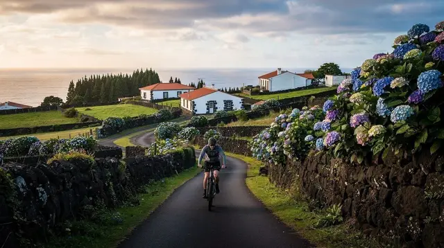
Near Ponta Delgada, Ribeira Grande and Lagoa it carries real traffic, including the dual-carriageway via rápida that links those towns — not a road built with cyclists in mind. Further out, toward Nordeste and around the south coast near Vila Franca do Campo, it narrows and quietens considerably, running close to the sea with far less traffic.
Away from the EN1-1A, the interior roads are narrower still — often a single lane and a half, with stone walls or hedgerow close on both sides, built to serve pasture and small farms rather than through-traffic. These roads are frequently where the steepest, most repeated gradient changes happen, since they climb directly from the coast toward the crater rims and highland plateaus rather than following an easier engineered line. Riders should expect blind bends, occasional livestock on the road, and stretches with no shoulder at all. This is a general picture of what the terrain and road network are like, not a route-by-route breakdown — a separate guide lays out specific loops and where they start and finish.
What a Day of Riding Actually Feels Like
On paper, a modest distance on São Miguel — say, 40 or 50 km — looks like an easy half-day. In practice, the elevation profile of that distance can rival a much longer ride on flatter ground, because so little of the island stays level for long. A route that touches the coast near Caloura and climbs toward the interior, for instance, gains and loses altitude repeatedly rather than settling into one long grade. Riders who plan by distance alone, without factoring in the terrain, consistently underestimate how long a route will take and how tired they will be by the end of it.
The reward for that effort is real: the climbs open onto views that a flatter ride could never offer — pasture running down to cliffs, the sudden appearance of a caldera lake, glimpses of the sea from unexpected angles. But it is worth planning rides with generous time margins, particularly later in the day when legs are tired and roads are narrow.
A rider who wants the climbing without the full physical toll increasingly turns to an assisted option — several operators run e-bike and e-gravel outings that flatten the effort curve while keeping the same terrain and views, among them a guided e-bike outing around Ponta Delgada and an e-gravel ride through the Furnas caldera. This guide does not cover bike rental logistics in detail — that is handled in a separate guide — but it is worth knowing the option exists before assuming every ride here has to be done unassisted.
Fog, Weather and Visibility on the Climbs
The Atlantic weather that shapes the whole island shapes cycling on it too, and higher ground is where it matters most. Lagoa do Fogo, the crater lake sitting roughly in the middle of the island, is often described on this site as frequently sitting inside cloud, and the road that climbs toward it is a clear example of how fast conditions can change.
A ride that starts in bright coastal sun can run into thick fog within a few hundred metres of altitude, cutting visibility sharply on roads that already have blind bends and no real shoulder. The same pattern shows up on the approach to viewpoints in the east, near Nordeste, where cloud can sit over the ridge while the coast below stays clear.
This is not a once-in-a-while hazard; it is a routine feature of riding the island’s higher roads, and it is worth planning around rather than hoping to avoid. Practical steps that matter more here than on a typical cycling trip: carry a light, even in summer, since visibility to drivers drops fast in fog; check conditions before committing to a climb into the interior, since a road that is fine at the coast can be socked in further up; and be willing to turn back or reroute rather than push on blind.
None of this is unique to cycling — the same fog closes the same roads to cars — but a cyclist has less protection and less ability to simply wait it out in a warm vehicle. For a broader sense of how conditions shift through the year, see the general weather guide, though day-to-day fog on high ground is its own separate pattern worth taking seriously on its own terms.
Who This Kind of Riding Actually Suits
Classic road and gravel cycling on São Miguel suits riders who want a genuine physical challenge on quiet, scenic roads and who are comfortable with constantly changing gradient rather than one predictable effort. It is a reasonable fit for anyone used to hilly training rides — the kind of terrain found in rolling coastal or farmland regions — rather than specifically alpine or high-mountain cycling. It does not particularly suit riders looking for long, flat, high-mileage days; the island’s shape makes that kind of ride hard to find outside short stretches near the larger towns.
It is also worth being honest that this is not a beginner-friendly island for long, ambitious solo routes. The combination of narrow roads, unpredictable weather on high ground, and constant elevation change asks more of both fitness and route judgement than the modest distances suggest.
Riders newer to road or gravel cycling, or those who want the scenery without the full physical demand, are generally better served either by shorter loops near a base like Ponta Delgada or by a supported and assisted outing — a guided gravel crossing from one coast to the other covers real distance and elevation with support along the way, which changes the calculation considerably compared to riding it solo and unsupported.
Renting a Vehicle Versus Riding: A Different Kind of Trip
Most visitors to São Miguel plan their days around a rental car, and it is worth being clear that a cycling day here is a genuinely different kind of trip, not a variation on the same itinerary at a slower pace. A driver can cover the Sete Cidades caldera, the north coast, and Furnas inside the same loose day, using the EN1-1A and interior roads interchangeably as convenience dictates.
A cyclist covering the same ground has to respect gradient, distance and weather in a way a car simply does not, and the honest comparison is closer to a full day’s effort for what a car manages in a couple of hours. That is not a reason to avoid cycling — it is a reason to plan a cycling day on its own terms, with its own distance and elevation budget, rather than trying to fold it into a driving itinerary built for a car. Anyone weighing how many days to allow for the island as a whole, cycling included, may find the general planning guide on how many days you need on São Miguel useful context before committing a full day to a ride.
Practical Preparation
A short, practical list matters more here than elsewhere, given how much the terrain and weather can shift within a single ride:
| Factor | What to expect |
|---|---|
| Elevation | Repeated short, steep climbs; no single long alpine-style ascent |
| High point | Pico da Vara, 1,103 m — not accessed by a through cycling road |
| Road surface | Mostly paved on the EN1-1A and main links; some interior and coastal stretches unpaved |
| Traffic | Heavier near Ponta Delgada, Ribeira Grande and Lagoa; lighter further out |
| Fog risk | Common on higher ground, especially near Lagoa do Fogo; can arrive with little warning |
| Shoulder space | Narrow to none on most interior roads |
Riders should carry lights regardless of planned finish time, layer clothing for temperature swings between coast and interior, and treat any climb toward the island’s higher ground — whether toward Lagoa do Fogo or the ridges near Nordeste — as a route that could turn foggy without warning.
A mobile signal is generally reliable near towns but can weaken in the interior, so it is worth telling someone the planned route and rough return time before setting out on a longer ride. For those who would rather have a guide manage the navigation, weather calls and mechanical support, a supported ride through the Furnas area removes most of that planning burden while keeping the same volcanic terrain underfoot.
Gearing and Bike Choice, in General Terms
Without laying out specific routes — that belongs to a dedicated guide — it is fair to say that gearing matters more here than distance alone would suggest. The repeated short, steep sections favour a wide gear range over raw top-end speed, which is part of why gravel bikes with a wider cassette have become a common choice for longer island crossings, alongside more traditional road setups for riders sticking closer to paved routes near town.
Tyre choice follows from the same logic: some sections mix paved and unpaved surfaces, particularly further from the main towns, so a bike that can handle a rougher patch without drama is generally more forgiving than one built purely for smooth tarmac. None of this changes the core point — that the island’s cycling character comes from constant, repeated elevation change on narrow roads under changeable weather, not from one long defining climb.
Cycling on São Miguel: Common Questions
Is São Miguel a mountain-biking or alpine-cycling destination?
No. The terrain is volcanic and hilly, with steep short pitches rather than the long, engineered switchbacks of an alpine col. The island’s high point, Pico da Vara, sits at 1,103 m, but no road climbs it in the way a road climbs a glaciated mountain pass.
How hard is cycling on São Miguel for an average rider?
Expect frequent short, sharp climbs rather than one sustained effort. A fit recreational cyclist can manage a day out, but the constant up-and-down between sea level and the interior adds up to more elevation gain than the distance alone suggests.
Are the roads safe for cycling?
The roads are mostly narrow, with limited shoulder space, so riders share the lane with local traffic, farm vehicles and buses. The EN1-1A that rings the island carries more traffic than interior lanes, and visibility drops fast in fog on higher routes.
Does fog affect cycling routes?
Yes, particularly on higher ground such as the approach to Lagoa do Fogo, where cloud can settle over the road with little warning and cut visibility sharply. Riders should check conditions before heading into the interior and be ready to turn back.
Is there a single ring road around São Miguel for cycling?
The EN1-1A functions as the island’s main ring road and links most coastal towns, but it varies between quiet stretches and busier sections near Ponta Delgada, Ribeira Grande and Lagoa, so it is not a uniformly quiet cycling loop.
Do I need a road bike or a gravel bike on São Miguel?
Either can work depending on the route: paved roads cover most of the island, but some interior and coastal tracks are unpaved, which is why gravel bikes are commonly used for wider loops. This guide covers the terrain and difficulty in general; it does not lay out specific routes.
Can beginners cycle on São Miguel?
Beginners can ride shorter, flatter stretches near towns, but the island’s constant gradient changes and narrow roads make longer routes more demanding than they first appear on a map. Guided or supported rides are a reasonable way to start.
Where can I rent a bike or join a guided ride?
Bike rental, including e-bikes, is covered in a separate guide, and specific route recommendations are covered elsewhere too; this page focuses only on what the terrain and roads are actually like.
Cycling on GetYourGuide
Verified deep-linked GetYourGuide tours. Book through these links and we earn a small commission at no cost to you.
GetYourGuide does not provide a product photo for this activity — the image shows the meeting point, photographed by us.