What Canyoning on São Miguel Actually Looks Like
What is canyoning like on São Miguel?
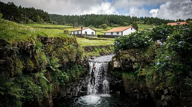
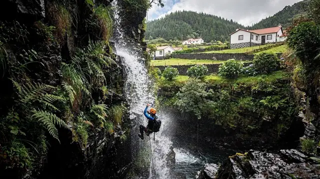
Canyoning on São Miguel takes place in green, water-carved ravines at low to moderate altitude, not in high mountains — the island has no glacier and no ski area, and its highest point, Pico da Vara, is only 1,103 m. Routes run through wooded gorges near sites such as Ribeira dos Caldeirões and Salto do Cabrito, combining jumps, slides, abseils and swims through pools fed by rain rather than snowmelt.
Ravines, not peaks: resetting what “canyoning” means here
Say the word canyoning to someone who has done it in the Pyrenees or the Alps, and they picture snowmelt roaring off a high wall, an approach on scree, maybe a hut above the tree line. None of that exists on São Miguel. This is a volcanic Atlantic island with no glacier and nothing resembling a ski domain, and its highest ground, Pico da Vara in the Serra da Tronqueira, tops out at 1,103 m — a serious hill by local standards, not a mountain in the Alpine sense.
Canyoning here happens well below that line, in green, water-cut ravines called ribeiras that thread through the island’s farmed and forested interior. The water in them comes from Atlantic rain, not a snowfield, and the walls are andesite and basalt softened by centuries of stream flow rather than exposed granite. It is a genuinely different sport wearing a familiar name, and getting that straight before you book changes what you should expect from the day.
Where these ravines actually sit on the island
São Miguel’s canyoning routes cluster in its wetter, greener valleys, above all around the Nordeste circuit, where the Ribeira dos Caldeirões cuts a narrow, forested gorge lined with old water mills, and around sites known locally as Salto do Cabrito. These valleys start close to sea level and climb gently into laurel forest and hydrangea hedgerow, the kind of landscape you also find on the walk to the Salto do Prego waterfall near Faial da Terra.
None of it is high-altitude terrain, and none of it connects to a summit route. A canyoning day and a mountain-summit day are simply not the same outing on this island — if you want the closest thing São Miguel has to a big vertical hike, that is the separate Lagoa do Fogo trail, which is walking, not water.
A typical descent, start to finish
A guided day usually opens with a kit fitting — wetsuit, helmet, harness — at a base near the ravine’s entry point, followed by a short walk in through forest to the first drop. From there, the route alternates between natural water slides worn smooth by centuries of flow, jumps of a few metres into deep, clear pools, short abseils beside cascades where the drop is too steep or the pool too shallow to jump, and long swims through narrow, shaded channels walled in ferns and moss.
Guides set the pace, choose which features each group member takes and which they bypass, and read the water level constantly. A route such as the guided waterpark-style circuit through the pools and slides of Ribeira dos Caldeirões is built around this rhythm — jump, slide, swim, repeat — through a gorge that never climbs far above the road it starts and ends near. Most outings run three to four hours door to door, groups are small, and everyone is back in dry clothes well before dinner.
No high route: what the elevation profile actually looks like
It is worth being blunt about the numbers, because they are the part visitors most often get wrong. São Miguel’s highest point is 1,103 m. A canyoning descent typically covers a few hundred vertical metres at most, starting a short walk from a parked van and finishing at another road or village, not at a hut or a col. There is no cable car on the island, no mountain refuge to overnight in, and no snowline to worry about at any time of year — none of that infrastructure exists here because the terrain never asks for it.
What the routes do have is dense vegetation, slick volcanic rock, and a lot of moving water, which is a different kind of demanding: technical footing and cold-water stamina rather than altitude or exposure. Understanding how the island’s volcanic ground actually formed helps explain why the rock underfoot behaves the way it does — porous, often mossy, and nothing like Alpine granite.
The weather variable: hour by hour, side by side
The single biggest operational factor in a São Miguel canyoning trip is not season but the island’s short-range weather, and it behaves in a way that surprises first-time visitors. Conditions here change hour by hour, and they change from one side of the island to another at the same time — it is entirely normal for a ravine in Furnas to be running high after a squall while Ponta Delgada, twenty-odd minutes away, sits under clear sky. That pattern is a direct consequence of the island’s shape and its position in the open Atlantic, and it is covered in more general terms in the São Miguel weather guide.
For canyoning specifically, it means guides make the call on the morning of the trip, not the week before: they check the ravine’s current flow, not just a forecast, and they will reroute to a lower, calmer section or postpone a start if a system has just passed through the interior. A cancelled morning slot does not necessarily mean a washed-out day everywhere else on the island — it usually just means that particular valley needs a few hours to drop back to a safe level. Rainfall patterns across the year, and what that means for planning around them, belong to a dedicated season guide rather than this page.
Grading, and matching a route to your group
Operators grade canyoning routes by technical difficulty and by how much swimming, jumping and abseiling each one demands, and a good guide will ask about swimming confidence and comfort with heights before confirming which route suits your group. A short, low-commitment circuit such as the waterpark-style descent works well for a first attempt or a family group with older kids, while a longer, more committed line like the full guided canyoning route at Salto do Cabrito suits people who already swim comfortably and want a longer, more varied gorge.
Fitness expectations and what a realistic skill threshold looks like are set out in full in a separate fitness and grading guide; this page is about the shape of the sport itself rather than who should choose which route. What packing list to bring is likewise its own topic, covered here rather than folded into this one.
Who canyoning suits — and who it doesn’t
Canyoning is physically demanding and cold-water tolerant by nature, but it does not require any prior rock-climbing or mountaineering experience — the technical judgement on anchors, lines and pace sits with the guide, not with each participant. That makes it a reasonable option for confident swimmers who have never done anything like it before, and a poor fit for anyone uneasy in moving water or unwilling to get thoroughly wet for three or four hours straight.
Families sometimes ask whether an introductory circuit works for older children rather than adults only; that question, along with the wider list of what suits younger visitors on the island, is answered in the family-friendly activities guide and in the broader São Miguel with kids planning guide rather than in detail here. What canyoning is not suited to is anyone hoping for a dry, scenic walk — for that, the island’s hiking guides, starting with the one to Lagoa do Fogo, are the better fit.
Canyoning, coasteering, and hiking: not the same activity
Because all three get loosely filed under “adventure” on the island, it helps to separate them plainly:
| Activity | Setting | Typical elevation | Water |
|---|---|---|---|
| Canyoning | Inland freshwater ravines | Sea level to a few hundred metres | Stream pools, slides, waterfalls |
| Coasteering | Open Atlantic coastline | Sea level, along cliffs and platforms | Ocean swell, sea caves |
| Hiking to Lagoa do Fogo | Interior crater rim and slopes | Up to roughly 900 m | None — a dry walking route |
If the ocean version appeals more than a freshwater gorge, a guided coasteering trip along the coast with a seaside picnic moves through a completely different environment — open swell and rock platforms rather than a forested ravine — and is worth reading about separately in the coasteering and coastline safety guide.
Neither activity has anything to do with the island’s one real high-altitude walk, the crater-rim route above Lagoa do Fogo — for anyone who would rather stay dry and stick to the crater rim on foot, a guided full-day hike up to Lagoa do Fogo covers that alternative directly.
Combining a canyoning day with the rest of the island
Because most canyoning routes sit in or near the Nordeste circuit, a canyoning morning pairs naturally with the rest of that side of the island — the waterfall park itself, the viewpoints further along the coast, and the laurel forest of the Serra da Tronqueira, home to the endemic priolo. Anyone building a full day around the area can use the Nordeste hiking itinerary to fill the hours either side of the water.
It is a useful reminder, too, that São Miguel rewards this kind of geographic pairing rather than a single big-ticket outing: the island is small enough that a ravine, a forest trail and a coastal viewpoint can all sit within the same half-day loop, none of them involving anything higher than a modest, green hill.
Wildlife and forest along the ravines
Because most canyoning routes on the island sit inside or beside the Nordeste circuit, the walk in and out often passes through the same laurel forest that shelters São Miguel’s rarest bird. The Serra da Tronqueira is the last stronghold of the priolo, the endemic Azores bullfinch, and the dedicated priolo guide explains why this unassuming stretch of forest matters so much to the species’ survival.
The bird is not part of the canyoning route itself — guides are there for the water, not for spotting — but anyone spending a morning in these ravines is already standing in its last remaining habitat, and a short detour afterwards onto the Serra da Tronqueira priolo trail is an easy way to see the same forest without a wetsuit on.
Basing yourself nearby
Most operators collect groups from a central meeting point and drive out to the ravine, so where you sleep matters less for the logistics of the day itself than for how the rest of it unfolds. Travellers based in Ponta Delgada generally treat a canyoning morning as an out-and-back day trip east, returning to the capital by evening; those staying nearer Furnas or along the Nordeste coast can instead fold the ravine into a slower loop that also takes in the Ponta do Sossego and Ponta da Madrugada viewpoints further along the coast road.
Either approach works; the choice really comes down to which side of the island you want to wake up on, a question covered in more depth in the Ponta Delgada versus Furnas base guide and in the island-wide where to stay overview.
When to book, and what else to plan around it
Canyoning slots depend on guide availability and, as covered above, on water levels that can shift overnight, which puts it on the shorter list of São Miguel activities worth locking in ahead of arrival rather than leaving to chance — a point made in general terms in the what to book in advance guide.
Rainfall and ravine conditions also vary across the calendar in ways that go beyond any single day’s forecast; the month-by-month guide and the best time to visit overview both cover how the wetter and drier stretches of the year affect outdoor activities generally, canyoning included, in more depth than fits on this page.
Canyoning on São Miguel: common questions before you book
Does canyoning on São Miguel involve mountains or glaciers?
No. São Miguel is a volcanic Atlantic island with no glacier and no ski domain. Its highest point, Pico da Vara, reaches 1,103 m, and canyoning routes sit well below that, in ravines carved into the island’s green interior rather than on any peak.
Where on the island does canyoning happen?
Guided routes run in ribeiras — stream-cut ravines — on the wetter parts of the island, including the Nordeste area around Ribeira dos Caldeirões and sites known locally as Salto do Cabrito. These are close to sea level rising to a few hundred metres, not high-altitude terrain.
What does a typical descent involve?
A wetsuit and helmet fitting, a short walk in, then a sequence of jumps into pools, natural slides over smoothed rock, short abseils beside waterfalls, and swims through narrow, ferned channels. Groups are usually out and dry again within three to four hours.
How does the weather affect a canyoning trip here?
São Miguel’s weather changes by the hour and differs from one side of the island to the other — rain can fall in Furnas while Ponta Delgada stays dry. Guides check water levels each morning and may adjust the route, delay the start, or cancel if a ravine is running too high.
Is this technical mountaineering, with ropes on rock and ice?
No. There is no ice, snow or exposed rock climbing involved. The ropework is limited to short water-side abseils beside waterfalls, and every descent is led by a certified local guide who sets the anchors.
Can beginners take part?
Yes — operators offer routes graded from introductory waterpark-style circuits to longer descents, and a guide adjusts pace and line choice on the day. Fitness and skill expectations are covered in a dedicated guide rather than here.
Is canyoning the same as coasteering on São Miguel?
No. Canyoning follows freshwater ravines inland, in the laurel-covered valleys of the interior. Coasteering happens on the open Atlantic coastline itself, moving along cliffs, rock platforms and sea caves rather than a stream bed.
What should I wear or bring canyoning on São Miguel?
Operators supply the technical gear — wetsuit, helmet and harness — so you mainly need swimwear to wear underneath, a towel and dry clothes for afterwards, and secure footwear if you own any. The full breakdown of what to bring and what to leave in the car belongs to a dedicated packing guide rather than this one.
Is canyoning on São Miguel suitable for families with children?
Shorter, waterpark-style circuits can suit families with older children who already swim confidently, while longer, more committed gorges are better matched to adults. Exact age and comfort thresholds vary by operator and route, and are covered in dedicated family-activity guides rather than here.
Canyoning on GetYourGuide
Verified deep-linked GetYourGuide tours. Book through these links and we earn a small commission at no cost to you.
GetYourGuide does not provide a product photo for this activity — the image shows the meeting point, photographed by us.